Dasburg geodata
Dasburg (Rheinland-Pfalz) is a seat of a fourth-order administrative division; located in Germany in Europe/Berlin (GMT+2) time zone. With population of 273 people, there are 10154 cities with bigger population in this country. Compared to other cities in Germany, 62.5% of cities are located further ↑North; 99.9% of cities are located further →East and 70.7% of cities have lower elevation than Dasburg. Note1
Administrative division(s):
- Level 1: Rheinland-Pfalz
- Level 3: Eifelkreis Bitburg-Prüm
- Level 4: Dasburg


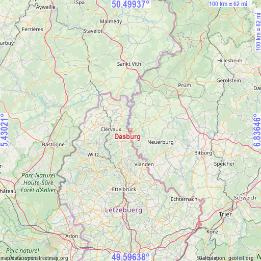
Dasburg GPS coordinates[2]
50° 3' 0" North, 6° 7' 59.988" East
| Map corner | latitude | longitude |
|---|---|---|
| Upper-left | 50.49937°, | 5.43021° |
| Center: | 50.05°, | 6.13333° |
| Lower-right: | 49.59638°, | 6.83646° |
| Map W x H: | 100.4×100.4 km | = 62.4×62.4mi |
| max Lat: | 55.01917° ⇑62.5% North |
| Dasburg: | 50.05° |
| min Lat: | ⇓37.5% South 47.40724° |
| min Long | Dasburg | max Long |
| 5.92978° | 6.13333° | 14.98853° |
| W 0.1%⇐ | ⇒99.9% E |
Elevation
Elevation of Dasburg is 364 m = 1194 ft, and this is 114.9 m = 377 ft above average elevation for this country.
| Max E: |
1256 m = 4121 ft | 29.3% |
| Dasburg | 364 m 1194 ft | |
| Avg. | 249.1 m = 817 ft | |
Min E: |
-5 m = -16 ft | 70.7% |
See also: Germany elevation on elevation.city.
Geographical zone
Dasburg is located in North temperate zone (between Tropic of Cancer and the Arctic Circle). Distance of this North polar circle is 1836.1 km =1140.9 mi to North.| Distance of | km | miles | from Dasburg |
|---|---|---|---|
| North Pole | 4442 | 2760.1 | to North |
| Arctic Circle | 1836.1 | 1140.9 | to North |
| Tropic Cancer | 2959.1 | 1838.7 | to South |
| Equator | 5565 | 3457.9 | to South |


Nearby cities:
15 places around Dasburg: (largest is in red/bold)
• Affler
3.9 km =2.4 mi,  162°
162°
• Dahnen
2.2 km =1.4 mi,  32°
32°
• Daleiden
4.2 km =2.6 mi,  58°
58°
• Dauwelshausen
6.6 km =4.1 mi,  147°
147°
• Gemünd
7.8 km =4.8 mi, 162°
• Herbstmühle
8.1 km =5 mi,  133°
133°
• Irrhausen
5.1 km =3.2 mi,  68°
68°
• Jucken
7.1 km =4.4 mi,  90°
90°
• Karlshausen
7.4 km =4.6 mi,  113°
113°
• Olmscheid
6.2 km =3.9 mi, 72°
• Preischeid
2.2 km =1.4 mi, 147°
• Reiff
7.3 km =4.5 mi,  40°
40°
• Reipeldingen
5.1 km =3.2 mi, 43°
• Scheitenkorb
6 km =3.7 mi, 127°
• Übereisenbach
5.7 km =3.5 mi,  167°
167°
Sources, notices
• [Note1] Compared only with cities in Germany existing in our database
• [Src1] Map data: © OpenStreetMap contributors (CC-BY-SA)
• [Src2] Other city data from geonames.org with taken over terms of usage.
• [Src3] Geographical zone / Annual Mean Temperature by Robert A. Rohde @ Wikipedia
