Horst geodata
Horst (Schleswig-Holstein) is a populated place; located in Germany in Europe/Berlin (GMT+2) time zone. With population of 5,183 people, there are 2749 cities with bigger population in this country. Compared to other cities in Germany, 90.2% of cities are located further ↓South; 55.7% of cities are located further →East and 93.1% of cities have higher elevation than Horst. Note1
Administrative division(s):
- Level 1: Schleswig-Holstein
- Level 3: Kreis Steinburg
- Level 4: Horst (Holstein)


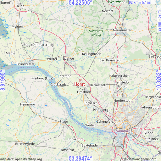
Horst GPS coordinates[2]
53° 48' 43.02" North, 9° 37' 23.052" East
| Map corner | latitude | longitude |
|---|---|---|
| Upper-left | 54.22505°, | 8.91995° |
| Center: | 53.81195°, | 9.62307° |
| Lower-right: | 53.39474°, | 10.3262° |
| Map W x H: | 92.3×92.3 km | = 57.4×57.4mi |
| max Lat: | 55.01917° ⇑9.8% North |
| Horst: | 53.81195° |
| min Lat: | ⇓90.2% South 47.40724° |
| min Long | Horst | max Long |
| 5.92978° | 9.62307° | 14.98853° |
| W 44.3%⇐ | ⇒55.7% E |
Elevation
Elevation of Horst is 13 m = 43 ft, and this is 236.1 m = 775 ft below average elevation for this country.
| Max E: |
1256 m = 4121 ft | 93.1% |
| Avg. | 249.1 m = 817 ft | |
| Horst | 13 m = 43 ft | |
Min E: |
-5 m = -16 ft | 6.9% |
See also: Germany elevation on elevation.city.
Geographical zone
Horst is located in North temperate zone (between Tropic of Cancer and the Arctic Circle). Distance of this North polar circle is 1417.8 km =881 mi to North.| Distance of | km | miles | from Horst |
|---|---|---|---|
| North Pole | 4023.7 | 2500.2 | to North |
| Arctic Circle | 1417.8 | 881 | to North |
| Tropic Cancer | 3377.4 | 2098.6 | to South |
| Equator | 5983.3 | 3717.8 | to South |


Nearby cities:
15 places around Horst: (largest is in red/bold)
• Altenmoor
6.3 km =3.9 mi,  216°
216°
• Brande-Hörnerkirchen
7.5 km =4.7 mi,  55°
55°
• Elmshorn
6.7 km =4.2 mi,  162°
162°
• Grevenkop
6.8 km =4.2 mi,  300°
300°
• Groß Offenseth-Aspern
7.3 km =4.5 mi,  85°
85°
• Hohenfelde
3.5 km =2.2 mi,  359°
359°
• Kiebitzreihe
3.2 km =2 mi,  187°
187°
• Klein Offenseth-Sparrieshoop
4.5 km =2.8 mi,  111°
111°
• Kölln-Reisiek
7.8 km =4.8 mi,  141°
141°
• Osterhorn
7.9 km =4.9 mi,  39°
39°
• Raa-Besenbek
7.3 km =4.5 mi, 194°
• Rethwisch
6.6 km =4.1 mi,  338°
338°
• Sommerland
5.7 km =3.5 mi,  260°
260°
• Süderau
7 km =4.3 mi,  274°
274°
• Westerhorn
6.2 km =3.9 mi, 36°
Sources, notices
• [Note1] Compared only with cities in Germany existing in our database
• [Src1] Map data: © OpenStreetMap contributors (CC-BY-SA)
• [Src2] Other city data from geonames.org with taken over terms of usage.
• [Src3] Geographical zone / Annual Mean Temperature by Robert A. Rohde @ Wikipedia
