Raa-Besenbek geodata
Raa-Besenbek (Schleswig-Holstein) is a seat of a fourth-order administrative division; located in Germany in Europe/Berlin (GMT+2) time zone. With population of 516 people, there are 9283 cities with bigger population in this country. Compared to other cities in Germany, 89.3% of cities are located further ↓South; 56.3% of cities are located further →East and 98.6% of cities have higher elevation than Raa-Besenbek. Note1
Administrative division(s):
- Level 1: Schleswig-Holstein
- Level 3: Kreis Pinneberg
- Level 4: Raa-Besenbek


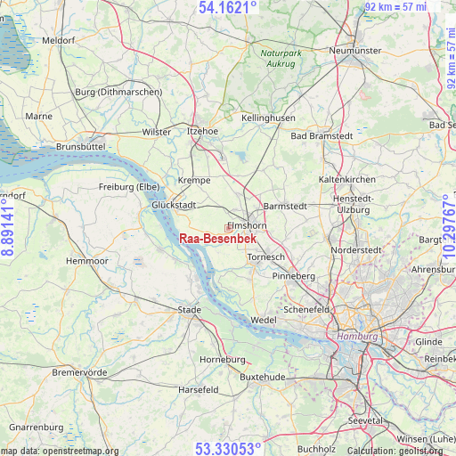
Raa-Besenbek GPS coordinates[2]
53° 44' 54.132" North, 9° 35' 40.344" East
| Map corner | latitude | longitude |
|---|---|---|
| Upper-left | 54.1621°, | 8.89141° |
| Center: | 53.74837°, | 9.59454° |
| Lower-right: | 53.33053°, | 10.29767° |
| Map W x H: | 92.5×92.5 km | = 57.5×57.5mi |
| max Lat: | 55.01917° ⇑10.7% North |
| Raa-Besenbek: | 53.74837° |
| min Lat: | ⇓89.3% South 47.40724° |
| min Long | Raa-Besenbek | max Long |
| 5.92978° | 9.59454° | 14.98853° |
| W 43.7%⇐ | ⇒56.3% E |
Elevation
Elevation of Raa-Besenbek is 1 m = 3 ft, and this is 248.1 m = 814 ft below average elevation for this country.
| Max E: |
1256 m = 4121 ft | 98.6% |
| Avg. | 249.1 m = 817 ft | |
| Raa-Besenbek | 1 m = 3 ft | |
Min E: |
-5 m = -16 ft | 1.4% |
See also: Germany elevation on elevation.city.
Geographical zone
Raa-Besenbek is located in North temperate zone (between Tropic of Cancer and the Arctic Circle). Distance of this North polar circle is 1424.9 km =885.4 mi to North.| Distance of | km | miles | from Raa-Besenbek |
|---|---|---|---|
| North Pole | 4030.8 | 2504.6 | to North |
| Arctic Circle | 1424.9 | 885.4 | to North |
| Tropic Cancer | 3370.3 | 2094.2 | to South |
| Equator | 5976.3 | 3713.5 | to South |


Nearby cities:
15 places around Raa-Besenbek: (largest is in red/bold)
• Altenmoor
2.7 km =1.7 mi,  318°
318°
• Elmshorn
3.9 km =2.4 mi,  80°
80°
• Groß Nordende
6.5 km =4 mi,  145°
145°
• Heidgraben
7.3 km =4.5 mi,  128°
128°
• Horst
7.3 km =4.5 mi,  14°
14°
• Kiebitzreihe
4.2 km =2.6 mi,  20°
20°
• Klein Nordende
4.9 km =3 mi, 126°
• Klein Offenseth-Sparrieshoop
8.1 km =5 mi,  47°
47°
• Kollmar
7.9 km =4.9 mi,  254°
254°
• Kölln-Reisiek
6.9 km =4.3 mi, 81°
• Neuendeich
7.4 km =4.6 mi,  168°
168°
• Neuendorf
2.4 km =1.5 mi,  240°
240°
• Seester
3.4 km =2.1 mi,  176°
176°
• Seestermühe
5.7 km =3.5 mi,  198°
198°
• Sommerland
7.2 km =4.5 mi,  328°
328°
Sources, notices
• [Note1] Compared only with cities in Germany existing in our database
• [Src1] Map data: © OpenStreetMap contributors (CC-BY-SA)
• [Src2] Other city data from geonames.org with taken over terms of usage.
• [Src3] Geographical zone / Annual Mean Temperature by Robert A. Rohde @ Wikipedia
