Hollingstedt geodata
Hollingstedt (Schleswig-Holstein) is a seat of a fourth-order administrative division; located in Germany in Europe/Berlin (GMT+2) time zone. With population of 1,021 people, there are 7109 cities with bigger population in this country. Compared to other cities in Germany, 97.8% of cities are located further ↓South; 60.2% of cities are located further →East and 98.1% of cities have higher elevation than Hollingstedt. Note1
Administrative division(s):
- Level 1: Schleswig-Holstein
- Level 3: Kreis Schleswig-Flensburg
- Level 4: Hollingstedt


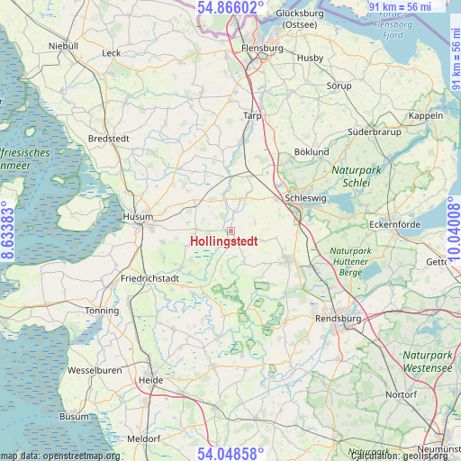
Hollingstedt GPS coordinates[2]
54° 27' 33.624" North, 9° 20' 13.02" East
| Map corner | latitude | longitude |
|---|---|---|
| Upper-left | 54.86602°, | 8.63383° |
| Center: | 54.45934°, | 9.33695° |
| Lower-right: | 54.04858°, | 10.04008° |
| Map W x H: | 90.9×90.9 km | = 56.5×56.5mi |
| max Lat: | 55.01917° ⇑2.2% North |
| Hollingstedt: | 54.45934° |
| min Lat: | ⇓97.8% South 47.40724° |
| min Long | Hollingstedt | max Long |
| 5.92978° | 9.33695° | 14.98853° |
| W 39.8%⇐ | ⇒60.2% E |
Elevation
Elevation of Hollingstedt is 2 m = 7 ft, and this is 247.1 m = 811 ft below average elevation for this country.
| Max E: |
1256 m = 4121 ft | 98.1% |
| Avg. | 249.1 m = 817 ft | |
| Hollingstedt | 2 m = 7 ft | |
Min E: |
-5 m = -16 ft | 1.9% |
See also: Germany elevation on elevation.city.
Geographical zone
Hollingstedt is located in North temperate zone (between Tropic of Cancer and the Arctic Circle). Distance of this North polar circle is 1345.9 km =836.3 mi to North.| Distance of | km | miles | from Hollingstedt |
|---|---|---|---|
| North Pole | 3951.8 | 2455.5 | to North |
| Arctic Circle | 1345.9 | 836.3 | to North |
| Tropic Cancer | 3449.4 | 2143.4 | to South |
| Equator | 6055.3 | 3762.6 | to South |


Nearby cities:
15 places around Hollingstedt: (largest is in red/bold)
• Bergenhusen
8.6 km =5.3 mi,  188°
188°
• Börm
7.2 km =4.5 mi,  155°
155°
• Dörpstedt
3.5 km =2.2 mi,  146°
146°
• Ellingstedt
5.1 km =3.2 mi,  70°
70°
• Fresendelf
9.3 km =5.8 mi,  218°
218°
• Groß Rheide
6.6 km =4.1 mi,  107°
107°
• Klein Rheide
9.5 km =5.9 mi,  96°
96°
• Ostenfeld
6.7 km =4.2 mi,  274°
274°
• Oster-Ohrstedt
9.7 km =6 mi,  309°
309°
• Silberstedt
7 km =4.3 mi,  25°
25°
• Treia
4.7 km =2.9 mi,  343°
343°
• Westerholz
5.4 km =3.4 mi, 309°
• Winnert
9.3 km =5.8 mi,  251°
251°
• Wittbek
8.9 km =5.5 mi,  275°
275°
• Wohlde
6.4 km =4 mi,  202°
202°
Sources, notices
• [Note1] Compared only with cities in Germany existing in our database
• [Src1] Map data: © OpenStreetMap contributors (CC-BY-SA)
• [Src2] Other city data from geonames.org with taken over terms of usage.
• [Src3] Geographical zone / Annual Mean Temperature by Robert A. Rohde @ Wikipedia
