Hinzenburg geodata
Hinzenburg (Rheinland-Pfalz) is a seat of a fourth-order administrative division; located in Germany in Europe/Berlin (GMT+2) time zone. With population of 133 people, there are 10751 cities with bigger population in this country. Compared to other cities in Germany, 72.2% of cities are located further ↑North; 96.2% of cities are located further →East and 76.5% of cities have lower elevation than Hinzenburg. Note1
Administrative division(s):
- Level 1: Rheinland-Pfalz
- Level 3: Landkreis Trier-Saarburg
- Level 4: Hinzenburg


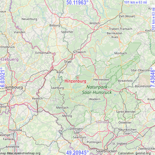
Hinzenburg GPS coordinates[2]
49° 40' 0.012" North, 6° 43' 59.988" East
| Map corner | latitude | longitude |
|---|---|---|
| Upper-left | 50.11963°, | 6.03021° |
| Center: | 49.66667°, | 6.73333° |
| Lower-right: | 49.20945°, | 7.43646° |
| Map W x H: | 101.2×101.2 km | = 62.9×62.9mi |
| max Lat: | 55.01917° ⇑72.2% North |
| Hinzenburg: | 49.66667° |
| min Lat: | ⇓27.8% South 47.40724° |
| min Long | Hinzenburg | max Long |
| 5.92978° | 6.73333° | 14.98853° |
| W 3.8%⇐ | ⇒96.2% E |
Elevation
Elevation of Hinzenburg is 409 m = 1342 ft, and this is 159.9 m = 525 ft above average elevation for this country.
| Max E: |
1256 m = 4121 ft | 23.5% |
| Hinzenburg | 409 m 1342 ft | |
| Avg. | 249.1 m = 817 ft | |
Min E: |
-5 m = -16 ft | 76.5% |
See also: Germany elevation on elevation.city.
Geographical zone
Hinzenburg is located in North temperate zone (between Tropic of Cancer and the Arctic Circle). Distance of this North polar circle is 1878.8 km =1167.4 mi to North.| Distance of | km | miles | from Hinzenburg |
|---|---|---|---|
| North Pole | 4484.6 | 2786.6 | to North |
| Arctic Circle | 1878.8 | 1167.4 | to North |
| Tropic Cancer | 2916.5 | 1812.2 | to South |
| Equator | 5522.4 | 3431.5 | to South |


Nearby cities:
15 places around Hinzenburg: (largest is in red/bold)
• Franzenheim
4 km =2.5 mi,  297°
297°
• Gusterath
3.9 km =2.4 mi,  342°
342°
• Gutweiler
5.6 km =3.5 mi,  0°
0°
• Heddert
2.2 km =1.4 mi,  147°
147°
• Hockweiler
5 km =3.1 mi,  323°
323°
• Holzerath
2.4 km =1.5 mi,  54°
54°
• Lampaden
3 km =1.9 mi,  232°
232°
• Ollmuth
1.2 km =0.7 mi,  270°
270°
• Paschel
5.2 km =3.2 mi,  224°
224°
• Pellingen
4.6 km =2.9 mi,  282°
282°
• Pluwig
3 km =1.9 mi,  329°
329°
• Riveris
6.1 km =3.8 mi,  23°
23°
• Schillingen
5.2 km =3.2 mi,  135°
135°
• Schömerich
4.4 km =2.7 mi,  212°
212°
• Sommerau
5.6 km =3.5 mi, 0°
Sources, notices
• [Note1] Compared only with cities in Germany existing in our database
• [Src1] Map data: © OpenStreetMap contributors (CC-BY-SA)
• [Src2] Other city data from geonames.org with taken over terms of usage.
• [Src3] Geographical zone / Annual Mean Temperature by Robert A. Rohde @ Wikipedia
