Hardisleben geodata
Hardisleben (Thuringia) is a seat of a fourth-order administrative division; located in Germany in Europe/Berlin (GMT+2) time zone. With population of 615 people, there are 8745 cities with bigger population in this country. Compared to other cities in Germany, 60.8% of cities are located further ↓South; 73.1% of cities are located further ←West and 56.1% of cities have higher elevation than Hardisleben. Note1


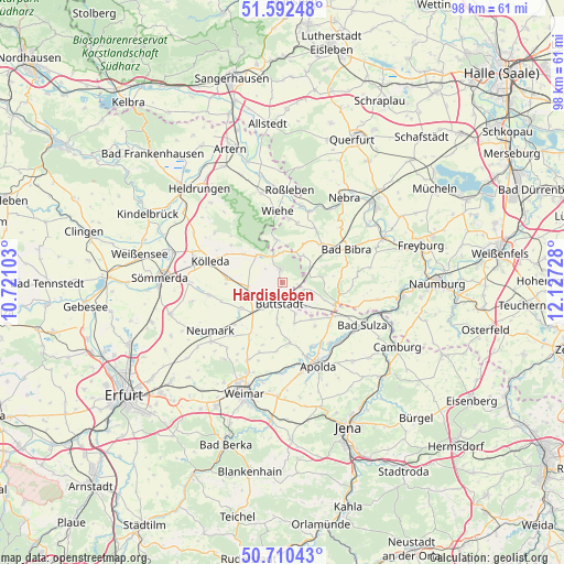
Hardisleben GPS coordinates[2]
51° 9' 12.816" North, 11° 25' 26.94" East
| Map corner | latitude | longitude |
|---|---|---|
| Upper-left | 51.59248°, | 10.72103° |
| Center: | 51.15356°, | 11.42415° |
| Lower-right: | 50.71043°, | 12.12728° |
| Map W x H: | 98.1×98.1 km | = 61×61mi |
| max Lat: | 55.01917° ⇑39.2% North |
| Hardisleben: | 51.15356° |
| min Lat: | ⇓60.8% South 47.40724° |
| min Long | Hardisleben | max Long |
| 5.92978° | 11.42415° | 14.98853° |
| W 73.1%⇐ | ⇒26.9% E |
Elevation
Elevation of Hardisleben is 181 m = 594 ft, and this is 68.1 m = 223 ft below average elevation for this country.
| Max E: |
1256 m = 4121 ft | 56.1% |
| Avg. | 249.1 m = 817 ft | |
| Hardisleben | 181 m = 594 ft | |
Min E: |
-5 m = -16 ft | 43.9% |
See also: Germany elevation on elevation.city.
Geographical zone
Hardisleben is located in North temperate zone (between Tropic of Cancer and the Arctic Circle). Distance of this North polar circle is 1713.4 km =1064.7 mi to North.| Distance of | km | miles | from Hardisleben |
|---|---|---|---|
| North Pole | 4319.3 | 2683.9 | to North |
| Arctic Circle | 1713.4 | 1064.7 | to North |
| Tropic Cancer | 3081.8 | 1914.9 | to South |
| Equator | 5687.7 | 3534.2 | to South |


Nearby cities:
15 places around Hardisleben: (largest is in red/bold)
• Billroda
5.6 km =3.5 mi,  23°
23°
• Buttstädt
3.5 km =2.2 mi,  187°
187°
• Ellersleben
7.5 km =4.7 mi,  266°
266°
• Guthmannshausen
4.6 km =2.9 mi,  240°
240°
• Herrengosserstedt
3.9 km =2.4 mi,  108°
108°
• Lossa
7.7 km =4.8 mi,  352°
352°
• Mannstedt
3.6 km =2.2 mi,  231°
231°
• Niederreißen
6.1 km =3.8 mi, 188°
• Nirmsdorf
7.3 km =4.5 mi,  153°
153°
• Oberreißen
7.4 km =4.6 mi, 186°
• Olbersleben
6.3 km =3.9 mi, 266°
• Ostramondra
8.2 km =5.1 mi,  309°
309°
• Rastenberg
2.4 km =1.5 mi, 353°
• Rudersdorf
6.2 km =3.9 mi,  163°
163°
• Willerstedt
7.4 km =4.6 mi, 164°
Sources, notices
• [Note1] Compared only with cities in Germany existing in our database
• [Src1] Map data: © OpenStreetMap contributors (CC-BY-SA)
• [Src2] Other city data from geonames.org with taken over terms of usage.
• [Src3] Geographical zone / Annual Mean Temperature by Robert A. Rohde @ Wikipedia
