Kaisheim geodata
Kaisheim (Bavaria) is a populated place; located in Germany in Europe/Berlin (GMT+2) time zone. With population of 4,344 people, there are 3113 cities with bigger population in this country. Compared to other cities in Germany, 85.7% of cities are located further ↑North; 64% of cities are located further ←West and 85.8% of cities have lower elevation than Kaisheim. Note1
Administrative division(s):
- Level 1: Bavaria
- Level 2: Swabia
- Level 3: Landkreis Donau-Ries
- Level 4: Kaisheim, Markt


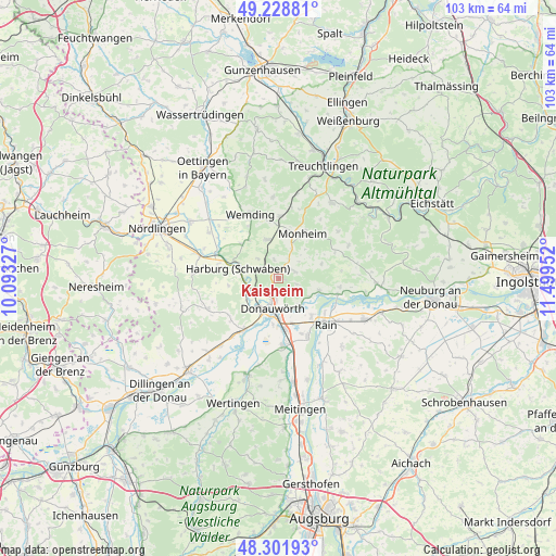
Kaisheim GPS coordinates[2]
48° 46' 3.036" North, 10° 47' 47.004" East
| Map corner | latitude | longitude |
|---|---|---|
| Upper-left | 49.22881°, | 10.09327° |
| Center: | 48.76751°, | 10.79639° |
| Lower-right: | 48.30193°, | 11.49952° |
| Map W x H: | 103.1×103.1 km | = 64.1×64.1mi |
| max Lat: | 55.01917° ⇑85.7% North |
| Kaisheim: | 48.76751° |
| min Lat: | ⇓14.3% South 47.40724° |
| min Long | Kaisheim | max Long |
| 5.92978° | 10.79639° | 14.98853° |
| W 64%⇐ | ⇒36% E |
Elevation
Elevation of Kaisheim is 475 m = 1558 ft, and this is 225.9 m = 741 ft above average elevation for this country.
| Max E: |
1256 m = 4121 ft | 14.2% |
| Kaisheim | 475 m 1558 ft | |
| Avg. | 249.1 m = 817 ft | |
Min E: |
-5 m = -16 ft | 85.8% |
See also: Germany elevation on elevation.city.
Geographical zone
Kaisheim is located in North temperate zone (between Tropic of Cancer and the Arctic Circle). Distance of this North polar circle is 1978.7 km =1229.5 mi to North.| Distance of | km | miles | from Kaisheim |
|---|---|---|---|
| North Pole | 4584.6 | 2848.7 | to North |
| Arctic Circle | 1978.7 | 1229.5 | to North |
| Tropic Cancer | 2816.5 | 1750.1 | to South |
| Equator | 5422.4 | 3369.3 | to South |


Nearby cities:
15 places around Kaisheim: (largest is in red/bold)
• Asbach-Bäumenheim
9.5 km =5.9 mi,  170°
170°
• Buchdorf
3.2 km =2 mi,  56°
56°
• Daiting
8.4 km =5.2 mi,  71°
71°
• Donauwörth
5.6 km =3.5 mi,  192°
192°
• Fünfstetten
7.5 km =4.7 mi,  342°
342°
• Genderkingen
9.8 km =6.1 mi,  139°
139°
• Harburg
8.1 km =5 mi,  285°
285°
• Huisheim
9.4 km =5.8 mi,  313°
313°
• Marxheim
11.3 km =7 mi,  104°
104°
• Mertingen
12.3 km =7.6 mi,  176°
176°
• Monheim
9.6 km =6 mi,  28°
28°
• Niederschönenfeld
11.5 km =7.1 mi,  119°
119°
• Oberndorf
12.1 km =7.5 mi,  154°
154°
• Otting
11.7 km =7.3 mi,  1°
1°
• Rain
12.3 km =7.6 mi,  134°
134°
Sources, notices
• [Note1] Compared only with cities in Germany existing in our database
• [Src1] Map data: © OpenStreetMap contributors (CC-BY-SA)
• [Src2] Other city data from geonames.org with taken over terms of usage.
• [Src3] Geographical zone / Annual Mean Temperature by Robert A. Rohde @ Wikipedia
