Handewitt geodata
Handewitt (Schleswig-Holstein) is a seat of a fourth-order administrative division; located in Germany in Europe/Berlin (GMT+2) time zone. With population of 6,152 people, there are 2414 cities with bigger population in this country. Compared to other cities in Germany, 99.5% of cities are located further ↓South; 60.3% of cities are located further →East and 82.8% of cities have higher elevation than Handewitt. Note1
Administrative division(s):
- Level 1: Schleswig-Holstein
- Level 3: Kreis Schleswig-Flensburg
- Level 4: Handewitt


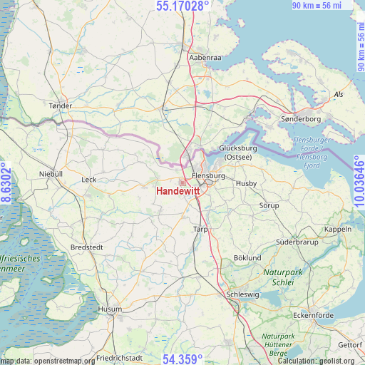
Handewitt GPS coordinates[2]
54° 46' 0.012" North, 9° 19' 59.988" East
| Map corner | latitude | longitude |
|---|---|---|
| Upper-left | 55.17028°, | 8.6302° |
| Center: | 54.76667°, | 9.33333° |
| Lower-right: | 54.359°, | 10.03646° |
| Map W x H: | 90.2×90.2 km | = 56×56mi |
| max Lat: | 55.01917° ⇑0.5% North |
| Handewitt: | 54.76667° |
| min Lat: | ⇓99.5% South 47.40724° |
| min Long | Handewitt | max Long |
| 5.92978° | 9.33333° | 14.98853° |
| W 39.7%⇐ | ⇒60.3% E |
Elevation
Elevation of Handewitt is 40 m = 131 ft, and this is 209.1 m = 686 ft below average elevation for this country.
| Max E: |
1256 m = 4121 ft | 82.8% |
| Avg. | 249.1 m = 817 ft | |
| Handewitt | 40 m = 131 ft | |
Min E: |
-5 m = -16 ft | 17.2% |
See also: Germany elevation on elevation.city.
Geographical zone
Handewitt is located in North temperate zone (between Tropic of Cancer and the Arctic Circle). Distance of this North polar circle is 1311.7 km =815.1 mi to North.| Distance of | km | miles | from Handewitt |
|---|---|---|---|
| North Pole | 3917.6 | 2434.3 | to North |
| Arctic Circle | 1311.7 | 815.1 | to North |
| Tropic Cancer | 3483.6 | 2164.6 | to South |
| Equator | 6089.5 | 3783.8 | to South |


Nearby cities:
15 places around Handewitt: (largest is in red/bold)
• Flensburg
7.1 km =4.4 mi,  73°
73°
• Freienwill
11.2 km =7 mi,  112°
112°
• Großenwiehe
9.1 km =5.7 mi,  215°
215°
• Harrislee
4.9 km =3 mi,  40°
40°
• Jarplund-Weding
6.4 km =4 mi,  121°
121°
• Lindewitt
11.3 km =7 mi,  229°
229°
• Meyn
7.2 km =4.5 mi,  262°
262°
• Nordhackstedt
11.3 km =7 mi,  250°
250°
• Oeversee
9.8 km =6.1 mi,  139°
139°
• Osterby
8.3 km =5.2 mi,  296°
296°
• Sankelmark
7.9 km =4.9 mi,  133°
133°
• Schafflund
9.7 km =6 mi, 264°
• Tastrup
9.6 km =6 mi,  90°
90°
• Wallsbüll
6.3 km =3.9 mi,  279°
279°
• Wanderup
9.3 km =5.8 mi,  180°
180°
Sources, notices
• [Note1] Compared only with cities in Germany existing in our database
• [Src1] Map data: © OpenStreetMap contributors (CC-BY-SA)
• [Src2] Other city data from geonames.org with taken over terms of usage.
• [Src3] Geographical zone / Annual Mean Temperature by Robert A. Rohde @ Wikipedia
