Großenwiehe geodata
Großenwiehe (Schleswig-Holstein) is a seat of a fourth-order administrative division; located in Germany in Europe/Berlin (GMT+2) time zone. With population of 2,829 people, there are 4145 cities with bigger population in this country. Compared to other cities in Germany, 99.2% of cities are located further ↓South; 61.5% of cities are located further →East and 91.6% of cities have higher elevation than Großenwiehe. Note1
Administrative division(s):
- Level 1: Schleswig-Holstein
- Level 3: Kreis Schleswig-Flensburg
- Level 4: Großenwiehe


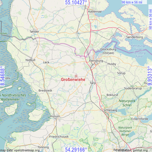
Großenwiehe GPS coordinates[2]
54° 42' 0" North, 9° 15' 0" East
| Map corner | latitude | longitude |
|---|---|---|
| Upper-left | 55.10427°, | 8.54688° |
| Center: | 54.7°, | 9.25° |
| Lower-right: | 54.29166°, | 9.95313° |
| Map W x H: | 90.4×90.4 km | = 56.2×56.2mi |
| max Lat: | 55.01917° ⇑0.8% North |
| Großenwiehe: | 54.7° |
| min Lat: | ⇓99.2% South 47.40724° |
| min Long | Großenwiehe | max Long |
| 5.92978° | 9.25° | 14.98853° |
| W 38.5%⇐ | ⇒61.5% E |
Elevation
Elevation of Großenwiehe is 17 m = 56 ft, and this is 232.1 m = 761 ft below average elevation for this country.
| Max E: |
1256 m = 4121 ft | 91.6% |
| Avg. | 249.1 m = 817 ft | |
| Großenwiehe | 17 m = 56 ft | |
Min E: |
-5 m = -16 ft | 8.4% |
See also: Germany elevation on elevation.city.
Geographical zone
Großenwiehe is located in North temperate zone (between Tropic of Cancer and the Arctic Circle). Distance of this North polar circle is 1319.1 km =819.7 mi to North.| Distance of | km | miles | from Großenwiehe |
|---|---|---|---|
| North Pole | 3925 | 2438.9 | to North |
| Arctic Circle | 1319.1 | 819.7 | to North |
| Tropic Cancer | 3476.2 | 2160 | to South |
| Equator | 6082.1 | 3779.2 | to South |


Nearby cities:
15 places around Großenwiehe: (largest is in red/bold)
• Goldebek
6.7 km =4.2 mi,  253°
253°
• Goldelund
9.8 km =6.1 mi,  259°
259°
• Handewitt
9.1 km =5.7 mi,  35°
35°
• Hörup
10.6 km =6.6 mi,  296°
296°
• Janneby
8.1 km =5 mi,  156°
156°
• Jerrishoe
9 km =5.6 mi,  122°
122°
• Joldelund
9.3 km =5.8 mi,  233°
233°
• Lindewitt
3.2 km =2 mi,  270°
270°
• Löwenstedt
10 km =6.2 mi,  209°
209°
• Meyn
6.7 km =4.2 mi,  344°
344°
• Nordhackstedt
6.5 km =4 mi, 304°
• Schafflund
7.8 km =4.8 mi,  326°
326°
• Tarp
10.3 km =6.4 mi,  111°
111°
• Wallsbüll
8.5 km =5.3 mi,  354°
354°
• Wanderup
5.7 km =3.5 mi, 109°
Sources, notices
• [Note1] Compared only with cities in Germany existing in our database
• [Src1] Map data: © OpenStreetMap contributors (CC-BY-SA)
• [Src2] Other city data from geonames.org with taken over terms of usage.
• [Src3] Geographical zone / Annual Mean Temperature by Robert A. Rohde @ Wikipedia
