Lettweiler geodata
Lettweiler (Rheinland-Pfalz) is a seat of a fourth-order administrative division; located in Germany in Europe/Berlin (GMT+2) time zone. With population of 242 people, there are 10297 cities with bigger population in this country. Compared to other cities in Germany, 70.6% of cities are located further ↑North; 82.5% of cities are located further →East and 70.6% of cities have lower elevation than Lettweiler. Note1
Administrative division(s):
- Level 1: Rheinland-Pfalz
- Level 3: Landkreis Bad Kreuznach
- Level 4: Lettweiler


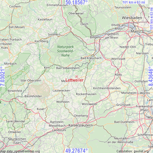
Lettweiler GPS coordinates[2]
49° 43' 59.988" North, 7° 43' 59.988" East
| Map corner | latitude | longitude |
|---|---|---|
| Upper-left | 50.18567°, | 7.03021° |
| Center: | 49.73333°, | 7.73333° |
| Lower-right: | 49.27674°, | 8.43646° |
| Map W x H: | 101.1×101.1 km | = 62.8×62.8mi |
| max Lat: | 55.01917° ⇑70.6% North |
| Lettweiler: | 49.73333° |
| min Lat: | ⇓29.4% South 47.40724° |
| min Long | Lettweiler | max Long |
| 5.92978° | 7.73333° | 14.98853° |
| W 17.5%⇐ | ⇒82.5% E |
Elevation
Elevation of Lettweiler is 363 m = 1191 ft, and this is 113.9 m = 374 ft above average elevation for this country.
| Max E: |
1256 m = 4121 ft | 29.4% |
| Lettweiler | 363 m 1191 ft | |
| Avg. | 249.1 m = 817 ft | |
Min E: |
-5 m = -16 ft | 70.6% |
See also: Germany elevation on elevation.city.
Geographical zone
Lettweiler is located in North temperate zone (between Tropic of Cancer and the Arctic Circle). Distance of this North polar circle is 1871.3 km =1162.8 mi to North.| Distance of | km | miles | from Lettweiler |
|---|---|---|---|
| North Pole | 4477.2 | 2782 | to North |
| Arctic Circle | 1871.3 | 1162.8 | to North |
| Tropic Cancer | 2923.9 | 1816.8 | to South |
| Equator | 5529.8 | 3436.1 | to South |


Nearby cities:
15 places around Lettweiler: (largest is in red/bold)
• Callbach
4.4 km =2.7 mi,  212°
212°
• Duchroth
5.6 km =3.5 mi,  0°
0°
• Feilbingert
6.1 km =3.8 mi,  52°
52°
• Finkenbach-Gersweiler
5.7 km =3.5 mi,  167°
167°
• Hallgarten
4.9 km =3 mi, 54°
• Meisenheim
5.5 km =3.4 mi,  238°
238°
• Niedermoschel
4.8 km =3 mi,  90°
90°
• Obermoschel
2.9 km =1.8 mi,  101°
101°
• Oberndorf
6.3 km =3.9 mi,  107°
107°
• Odernheim
4.1 km =2.5 mi,  329°
329°
• Rehborn
3.6 km =2.2 mi,  270°
270°
• Schiersfeld
4.4 km =2.7 mi,  147°
147°
• Sitters
4 km =2.5 mi,  117°
117°
• Staudernheim
5.8 km =3.6 mi, 326°
• Unkenbach
2.2 km =1.4 mi, 147°
Sources, notices
• [Note1] Compared only with cities in Germany existing in our database
• [Src1] Map data: © OpenStreetMap contributors (CC-BY-SA)
• [Src2] Other city data from geonames.org with taken over terms of usage.
• [Src3] Geographical zone / Annual Mean Temperature by Robert A. Rohde @ Wikipedia
