Gunzenhausen geodata
Gunzenhausen (Bavaria) is a seat of a third-order administrative division; located in Germany in Europe/Berlin (GMT+2) time zone. With population of 16,477 people, there are 961 cities with bigger population in this country. Compared to other cities in Germany, 81.6% of cities are located further ↑North; 63.4% of cities are located further ←West and 79.5% of cities have lower elevation than Gunzenhausen. Note1
Administrative division(s):
- Level 1: Bavaria
- Level 2: Regierungsbezirk Mittelfranken
- Level 3: Landkreis Weißenburg-Gunzenhausen
- Level 4: Gunzenhausen


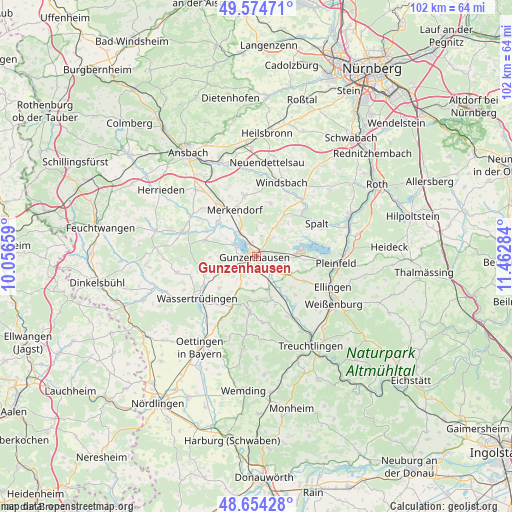
Gunzenhausen GPS coordinates[2]
49° 6' 59.868" North, 10° 45' 34.956" East
| Map corner | latitude | longitude |
|---|---|---|
| Upper-left | 49.57471°, | 10.05659° |
| Center: | 49.11663°, | 10.75971° |
| Lower-right: | 48.65428°, | 11.46284° |
| Map W x H: | 102.3×102.3 km | = 63.6×63.6mi |
| max Lat: | 55.01917° ⇑81.6% North |
| Gunzenhausen: | 49.11663° |
| min Lat: | ⇓18.4% South 47.40724° |
| min Long | Gunzenhausen | max Long |
| 5.92978° | 10.75971° | 14.98853° |
| W 63.4%⇐ | ⇒36.6% E |
Elevation
Elevation of Gunzenhausen is 430 m = 1411 ft, and this is 180.9 m = 594 ft above average elevation for this country.
| Max E: |
1256 m = 4121 ft | 20.5% |
| Gunzenhausen | 430 m 1411 ft | |
| Avg. | 249.1 m = 817 ft | |
Min E: |
-5 m = -16 ft | 79.5% |
See also: Germany elevation on elevation.city.
Geographical zone
Gunzenhausen is located in North temperate zone (between Tropic of Cancer and the Arctic Circle). Distance of this North polar circle is 1939.9 km =1205.4 mi to North.| Distance of | km | miles | from Gunzenhausen |
|---|---|---|---|
| North Pole | 4545.8 | 2824.6 | to North |
| Arctic Circle | 1939.9 | 1205.4 | to North |
| Tropic Cancer | 2855.3 | 1774.2 | to South |
| Equator | 5461.3 | 3393.5 | to South |


Nearby cities:
15 places around Gunzenhausen: (largest is in red/bold)
• Absberg
9.3 km =5.8 mi,  70°
70°
• Alesheim
10.9 km =6.8 mi,  135°
135°
• Arberg
10.8 km =6.7 mi,  286°
286°
• Dittenheim
7.2 km =4.5 mi,  160°
160°
• Gnotzheim
7.2 km =4.5 mi,  208°
208°
• Haundorf
6.7 km =4.2 mi,  7°
7°
• Heidenheim
11.1 km =6.9 mi,  186°
186°
• Meinheim
10.1 km =6.3 mi, 155°
• Merkendorf
10.5 km =6.5 mi,  337°
337°
• Mitteleschenbach
10.9 km =6.8 mi, 14°
• Muhr am See
5.2 km =3.2 mi,  324°
324°
• Ornbau
9.9 km =6.2 mi,  311°
311°
• Pfofeld
5.7 km =3.5 mi,  102°
102°
• Unterschwaningen
10.8 km =6.7 mi,  247°
247°
• Weidenbach
12.3 km =7.6 mi, 317°
Sources, notices
• [Note1] Compared only with cities in Germany existing in our database
• [Src1] Map data: © OpenStreetMap contributors (CC-BY-SA)
• [Src2] Other city data from geonames.org with taken over terms of usage.
• [Src3] Geographical zone / Annual Mean Temperature by Robert A. Rohde @ Wikipedia
