Dittenheim geodata
Dittenheim (Bavaria) is a seat of a fourth-order administrative division; located in Germany in Europe/Berlin (GMT+2) time zone. With population of 1,786 people, there are 5368 cities with bigger population in this country. Compared to other cities in Germany, 82.3% of cities are located further ↑North; 63.9% of cities are located further ←West and 79% of cities have lower elevation than Dittenheim. Note1
Administrative division(s):
- Level 1: Bavaria
- Level 2: Regierungsbezirk Mittelfranken
- Level 3: Landkreis Weißenburg-Gunzenhausen
- Level 4: Dittenheim


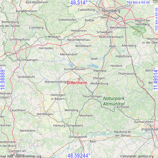
Dittenheim GPS coordinates[2]
49° 3' 19.296" North, 10° 47' 31.236" East
| Map corner | latitude | longitude |
|---|---|---|
| Upper-left | 49.514°, | 10.08889° |
| Center: | 49.05536°, | 10.79201° |
| Lower-right: | 48.59244°, | 11.49514° |
| Map W x H: | 102.5×102.5 km | = 63.7×63.7mi |
| max Lat: | 55.01917° ⇑82.3% North |
| Dittenheim: | 49.05536° |
| min Lat: | ⇓17.7% South 47.40724° |
| min Long | Dittenheim | max Long |
| 5.92978° | 10.79201° | 14.98853° |
| W 63.9%⇐ | ⇒36.1% E |
Elevation
Elevation of Dittenheim is 427 m = 1401 ft, and this is 177.9 m = 584 ft above average elevation for this country.
| Max E: |
1256 m = 4121 ft | 21% |
| Dittenheim | 427 m 1401 ft | |
| Avg. | 249.1 m = 817 ft | |
Min E: |
-5 m = -16 ft | 79% |
See also: Germany elevation on elevation.city.
Geographical zone
Dittenheim is located in North temperate zone (between Tropic of Cancer and the Arctic Circle). Distance of this North polar circle is 1946.7 km =1209.6 mi to North.| Distance of | km | miles | from Dittenheim |
|---|---|---|---|
| North Pole | 4552.6 | 2828.9 | to North |
| Arctic Circle | 1946.7 | 1209.6 | to North |
| Tropic Cancer | 2848.5 | 1770 | to South |
| Equator | 5454.4 | 3389.2 | to South |


Nearby cities:
15 places around Dittenheim: (largest is in red/bold)
• Absberg
11.8 km =7.3 mi,  33°
33°
• Alesheim
5.4 km =3.4 mi,  100°
100°
• Auhausen
13.4 km =8.3 mi,  246°
246°
• Ellingen
12.8 km =8 mi,  87°
87°
• Gnotzheim
5.8 km =3.6 mi,  274°
274°
• Gunzenhausen
7.2 km =4.5 mi,  340°
340°
• Haundorf
13.5 km =8.4 mi,  353°
353°
• Heidenheim
5.5 km =3.4 mi,  219°
219°
• Markt Berolzheim
6.4 km =4 mi,  142°
142°
• Meinheim
3 km =1.9 mi, 143°
• Muhr am See
12.3 km =7.6 mi,  334°
334°
• Pfofeld
6.5 km =4 mi, 30°
• Unterschwaningen
12.7 km =7.9 mi,  282°
282°
• Weißenburg in Bayern
13.4 km =8.3 mi, 101°
• Westheim
11 km =6.8 mi,  236°
236°
Sources, notices
• [Note1] Compared only with cities in Germany existing in our database
• [Src1] Map data: © OpenStreetMap contributors (CC-BY-SA)
• [Src2] Other city data from geonames.org with taken over terms of usage.
• [Src3] Geographical zone / Annual Mean Temperature by Robert A. Rohde @ Wikipedia
