Gundremmingen geodata
Gundremmingen (Bavaria) is a seat of a fourth-order administrative division; located in Germany in Europe/Berlin (GMT+2) time zone. With population of 1,502 people, there are 5875 cities with bigger population in this country. Compared to other cities in Germany, 89.2% of cities are located further ↑North; 57.1% of cities are located further ←West and 80.3% of cities have lower elevation than Gundremmingen. Note1
Administrative division(s):
- Level 1: Bavaria
- Level 2: Swabia
- Level 3: Landkreis Günzburg
- Level 4: Gundremmingen


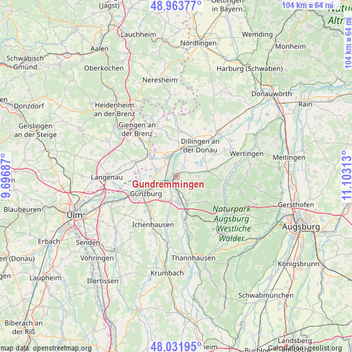
Gundremmingen GPS coordinates[2]
48° 30' 0" North, 10° 24' 0" East
| Map corner | latitude | longitude |
|---|---|---|
| Upper-left | 48.96377°, | 9.69687° |
| Center: | 48.5°, | 10.4° |
| Lower-right: | 48.03195°, | 11.10313° |
| Map W x H: | 103.6×103.6 km | = 64.4×64.4mi |
| max Lat: | 55.01917° ⇑89.2% North |
| Gundremmingen: | 48.5° |
| min Lat: | ⇓10.8% South 47.40724° |
| min Long | Gundremmingen | max Long |
| 5.92978° | 10.4° | 14.98853° |
| W 57.1%⇐ | ⇒42.9% E |
Elevation
Elevation of Gundremmingen is 435 m = 1427 ft, and this is 185.9 m = 610 ft above average elevation for this country.
| Max E: |
1256 m = 4121 ft | 19.7% |
| Gundremmingen | 435 m 1427 ft | |
| Avg. | 249.1 m = 817 ft | |
Min E: |
-5 m = -16 ft | 80.3% |
See also: Germany elevation on elevation.city.
Geographical zone
Gundremmingen is located in North temperate zone (between Tropic of Cancer and the Arctic Circle). Distance of this North polar circle is 2008.5 km =1248 mi to North.| Distance of | km | miles | from Gundremmingen |
|---|---|---|---|
| North Pole | 4614.4 | 2867.3 | to North |
| Arctic Circle | 2008.5 | 1248 | to North |
| Tropic Cancer | 2786.8 | 1731.6 | to South |
| Equator | 5392.7 | 3350.9 | to South |


Nearby cities:
15 places around Gundremmingen: (largest is in red/bold)
• Aislingen
4.3 km =2.7 mi,  80°
80°
• Burgau
7.6 km =4.7 mi,  174°
174°
• Bächingen an der Brenz
8.2 km =5.1 mi,  308°
308°
• Dürrlauingen
4.3 km =2.7 mi,  150°
150°
• Glött
6.1 km =3.8 mi,  90°
90°
• Gundelfingen
6.3 km =3.9 mi,  341°
341°
• Haldenwang
7.8 km =4.8 mi, 152°
• Holzheim
9.7 km =6 mi, 80°
• Lauingen
7.8 km =4.8 mi,  14°
14°
• Offingen
3.4 km =2.1 mi,  234°
234°
• Rettenbach
5.8 km =3.6 mi,  217°
217°
• Roßhaupten
9.4 km =5.8 mi, 147°
• Röfingen
9 km =5.6 mi,  159°
159°
• Sontheim an der Brenz
9.9 km =6.2 mi, 305°
• Winterbach
7.2 km =4.5 mi,  121°
121°
Sources, notices
• [Note1] Compared only with cities in Germany existing in our database
• [Src1] Map data: © OpenStreetMap contributors (CC-BY-SA)
• [Src2] Other city data from geonames.org with taken over terms of usage.
• [Src3] Geographical zone / Annual Mean Temperature by Robert A. Rohde @ Wikipedia
