Aislingen geodata
Aislingen (Bavaria) is a populated place; located in Germany in Europe/Berlin (GMT+2) time zone. With population of 1,455 people, there are 5970 cities with bigger population in this country. Compared to other cities in Germany, 89.1% of cities are located further ↑North; 58.2% of cities are located further ←West and 81.2% of cities have lower elevation than Aislingen. Note1
Administrative division(s):
- Level 1: Bavaria
- Level 2: Swabia
- Level 3: Landkreis Dillingen an der Donau
- Level 4: Aislingen, Markt


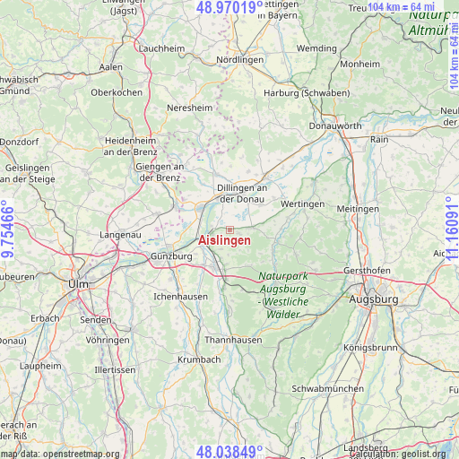
Aislingen GPS coordinates[2]
48° 30' 23.328" North, 10° 27' 28.008" East
| Map corner | latitude | longitude |
|---|---|---|
| Upper-left | 48.97019°, | 9.75466° |
| Center: | 48.50648°, | 10.45778° |
| Lower-right: | 48.03849°, | 11.16091° |
| Map W x H: | 103.6×103.6 km | = 64.4×64.4mi |
| max Lat: | 55.01917° ⇑89.1% North |
| Aislingen: | 48.50648° |
| min Lat: | ⇓10.9% South 47.40724° |
| min Long | Aislingen | max Long |
| 5.92978° | 10.45778° | 14.98853° |
| W 58.2%⇐ | ⇒41.8% E |
Elevation
Elevation of Aislingen is 441 m = 1447 ft, and this is 191.9 m = 630 ft above average elevation for this country.
| Max E: |
1256 m = 4121 ft | 18.8% |
| Aislingen | 441 m 1447 ft | |
| Avg. | 249.1 m = 817 ft | |
Min E: |
-5 m = -16 ft | 81.2% |
See also: Germany elevation on elevation.city.
Geographical zone
Aislingen is located in North temperate zone (between Tropic of Cancer and the Arctic Circle). Distance of this North polar circle is 2007.8 km =1247.6 mi to North.| Distance of | km | miles | from Aislingen |
|---|---|---|---|
| North Pole | 4613.6 | 2866.8 | to North |
| Arctic Circle | 2007.8 | 1247.6 | to North |
| Tropic Cancer | 2787.5 | 1732.1 | to South |
| Equator | 5393.4 | 3351.3 | to South |


Nearby cities:
15 places around Aislingen: (largest is in red/bold)
• Burgau
9 km =5.6 mi,  202°
202°
• Dillingen an der Donau
8.8 km =5.5 mi,  18°
18°
• Dürrlauingen
4.9 km =3 mi,  205°
205°
• Glött
2 km =1.2 mi,  110°
110°
• Gundelfingen
8.2 km =5.1 mi,  309°
309°
• Gundremmingen
4.3 km =2.7 mi,  260°
260°
• Haldenwang
7.7 km =4.8 mi,  185°
185°
• Holzheim
5.4 km =3.4 mi,  80°
80°
• Landensberg
9.4 km =5.8 mi,  148°
148°
• Lauingen
7.2 km =4.5 mi,  341°
341°
• Offingen
7.5 km =4.7 mi,  249°
249°
• Rettenbach
9.4 km =5.8 mi,  235°
235°
• Roßhaupten
8.6 km =5.3 mi,  174°
174°
• Röfingen
9.2 km =5.7 mi, 186°
• Winterbach
4.8 km =3 mi,  156°
156°
Sources, notices
• [Note1] Compared only with cities in Germany existing in our database
• [Src1] Map data: © OpenStreetMap contributors (CC-BY-SA)
• [Src2] Other city data from geonames.org with taken over terms of usage.
• [Src3] Geographical zone / Annual Mean Temperature by Robert A. Rohde @ Wikipedia
