Burgau geodata
Burgau (Bavaria) is a populated place; located in Germany in Europe/Berlin (GMT+2) time zone. With population of 9,576 people, there are 1688 cities with bigger population in this country. Compared to other cities in Germany, 89.9% of cities are located further ↑North; 57.2% of cities are located further ←West and 83.1% of cities have lower elevation than Burgau. Note1
Administrative division(s):
- Level 1: Bavaria
- Level 2: Swabia
- Level 3: Landkreis Günzburg
- Level 4: Burgau


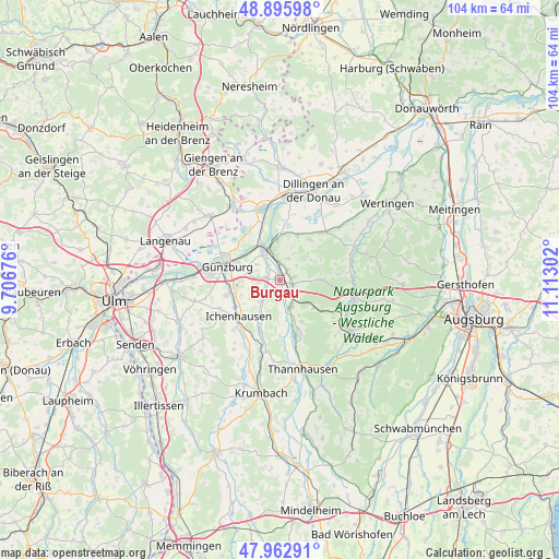
Burgau GPS coordinates[2]
48° 25' 53.724" North, 10° 24' 35.604" East
| Map corner | latitude | longitude |
|---|---|---|
| Upper-left | 48.89598°, | 9.70676° |
| Center: | 48.43159°, | 10.40989° |
| Lower-right: | 47.96291°, | 11.11302° |
| Map W x H: | 103.7×103.7 km | = 64.4×64.4mi |
| max Lat: | 55.01917° ⇑89.9% North |
| Burgau: | 48.43159° |
| min Lat: | ⇓10.1% South 47.40724° |
| min Long | Burgau | max Long |
| 5.92978° | 10.40989° | 14.98853° |
| W 57.2%⇐ | ⇒42.8% E |
Elevation
Elevation of Burgau is 454 m = 1490 ft, and this is 204.9 m = 672 ft above average elevation for this country.
| Max E: |
1256 m = 4121 ft | 16.9% |
| Burgau | 454 m 1490 ft | |
| Avg. | 249.1 m = 817 ft | |
Min E: |
-5 m = -16 ft | 83.1% |
See also: Germany elevation on elevation.city.
Geographical zone
Burgau is located in North temperate zone (between Tropic of Cancer and the Arctic Circle). Distance of this North polar circle is 2016.1 km =1252.7 mi to North.| Distance of | km | miles | from Burgau |
|---|---|---|---|
| North Pole | 4622 | 2872 | to North |
| Arctic Circle | 2016.1 | 1252.7 | to North |
| Tropic Cancer | 2779.2 | 1726.9 | to South |
| Equator | 5385.1 | 3346.1 | to South |


Nearby cities:
15 places around Burgau: (largest is in red/bold)
• Aislingen
9 km =5.6 mi,  22°
22°
• Dürrlauingen
4.1 km =2.5 mi, 19°
• Glött
9.3 km =5.8 mi,  35°
35°
• Gundremmingen
7.6 km =4.7 mi,  354°
354°
• Günzburg
10.2 km =6.3 mi,  285°
285°
• Haldenwang
2.9 km =1.8 mi,  76°
76°
• Ichenhausen
10.1 km =6.3 mi,  228°
228°
• Jettingen-Scheppach
5.1 km =3.2 mi,  155°
155°
• Landensberg
8.4 km =5.2 mi,  87°
87°
• Offingen
6.7 km =4.2 mi,  328°
328°
• Rettenbach
5.2 km =3.2 mi,  305°
305°
• Roßhaupten
4.4 km =2.7 mi, 93°
• Röfingen
2.5 km =1.6 mi,  108°
108°
• Wasserburg
10.4 km =6.5 mi,  275°
275°
• Winterbach
6.7 km =4.2 mi,  54°
54°
Sources, notices
• [Note1] Compared only with cities in Germany existing in our database
• [Src1] Map data: © OpenStreetMap contributors (CC-BY-SA)
• [Src2] Other city data from geonames.org with taken over terms of usage.
• [Src3] Geographical zone / Annual Mean Temperature by Robert A. Rohde @ Wikipedia
