Gültz geodata
Gültz (Mecklenburg-Vorpommern) is a populated place; located in Germany in Europe/Berlin (GMT+2) time zone. With population of 669 people, there are 8479 cities with bigger population in this country. Compared to other cities in Germany, 89.4% of cities are located further ↓South; 93.6% of cities are located further ←West and 77.3% of cities have higher elevation than Gültz. Note1
Administrative division(s):
- Level 1: Mecklenburg-Vorpommern
- Level 3: Mecklenburgische Seenplatte
- Level 4: Gültz


Gültz GPS coordinates[2]
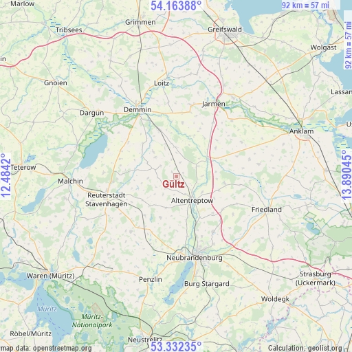
53° 45' 0.612" North, 13° 11' 14.352" East
| Map corner | latitude | longitude |
|---|---|---|
| Upper-left | 54.16388°, | 12.4842° |
| Center: | 53.75017°, | 13.18732° |
| Lower-right: | 53.33235°, | 13.89045° |
| Map W x H: | 92.5×92.5 km | = 57.5×57.5mi |
| max Lat: | 55.01917° ⇑10.6% North |
| Gültz: | 53.75017° |
| min Lat: | ⇓89.4% South 47.40724° |
| min Long | Gültz | max Long |
| 5.92978° | 13.18732° | 14.98853° |
| W 93.6%⇐ | ⇒6.4% E |
Elevation
Elevation of Gültz is 55 m = 180 ft, and this is 194.1 m = 637 ft below average elevation for this country.
| Max E: |
1256 m = 4121 ft | 77.3% |
| Avg. | 249.1 m = 817 ft | |
| Gültz | 55 m = 180 ft | |
Min E: |
-5 m = -16 ft | 22.7% |
See also: Germany elevation on elevation.city.
Geographical zone
Gültz is located in North temperate zone (between Tropic of Cancer and the Arctic Circle). Distance of this North polar circle is 1424.7 km =885.3 mi to North.| Distance of | km | miles | from Gültz |
|---|---|---|---|
| North Pole | 4030.6 | 2504.5 | to North |
| Arctic Circle | 1424.7 | 885.3 | to North |
| Tropic Cancer | 3370.5 | 2094.3 | to South |
| Equator | 5976.5 | 3713.6 | to South |


Nearby cities:
15 places around Gültz: (largest is in red/bold)
• Alt Tellin
11.1 km =6.9 mi,  19°
19°
• Altentreptow
8.1 km =5 mi,  140°
140°
• Bartow
12.8 km =8 mi,  54°
54°
• Beggerow
12.3 km =7.6 mi,  314°
314°
• Breesen
13.4 km =8.3 mi,  185°
185°
• Burow
6.2 km =3.9 mi,  65°
65°
• Groß Teetzleben
12 km =7.5 mi,  167°
167°
• Gützkow
6 km =3.7 mi,  241°
241°
• Kessin
8.3 km =5.2 mi,  106°
106°
• Reinberg
8.8 km =5.5 mi,  198°
198°
• Sarow
7.5 km =4.7 mi, 310°
• Siedenbollentin
12.9 km =8 mi,  98°
98°
• Tützpatz
4.1 km =2.5 mi,  224°
224°
• Wildberg
11.6 km =7.2 mi, 200°
• Wolde
10.4 km =6.5 mi, 221°
Sources, notices
• [Note1] Compared only with cities in Germany existing in our database
• [Src1] Map data: © OpenStreetMap contributors (CC-BY-SA)
• [Src2] Other city data from geonames.org with taken over terms of usage.
• [Src3] Geographical zone / Annual Mean Temperature by Robert A. Rohde @ Wikipedia
