Deesen geodata
Deesen (Rheinland-Pfalz) is a seat of a fourth-order administrative division; located in Germany in Europe/Berlin (GMT+2) time zone. With population of 672 people, there are 8465 cities with bigger population in this country. Compared to other cities in Germany, 52.6% of cities are located further ↑North; 83.1% of cities are located further →East and 50.1% of cities have lower elevation than Deesen. Note1


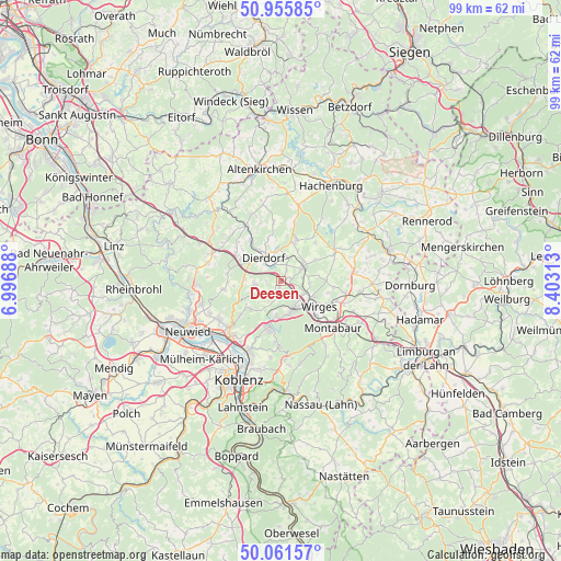
Deesen GPS coordinates[2]
50° 30' 38.988" North, 7° 42' 0" East
| Map corner | latitude | longitude |
|---|---|---|
| Upper-left | 50.95585°, | 6.99688° |
| Center: | 50.51083°, | 7.7° |
| Lower-right: | 50.06157°, | 8.40313° |
| Map W x H: | 99.4×99.4 km | = 61.8×61.8mi |
| max Lat: | 55.01917° ⇑52.6% North |
| Deesen: | 50.51083° |
| min Lat: | ⇓47.4% South 47.40724° |
| min Long | Deesen | max Long |
| 5.92978° | 7.7° | 14.98853° |
| W 16.9%⇐ | ⇒83.1% E |
Elevation
Elevation of Deesen is 226 m = 741 ft, and this is 23.1 m = 76 ft below average elevation for this country.
| Max E: |
1256 m = 4121 ft | 49.9% |
| Avg. | 249.1 m = 817 ft | |
| Deesen | 226 m = 741 ft | |
Min E: |
-5 m = -16 ft | 50.1% |
See also: Germany elevation on elevation.city.
Geographical zone
Deesen is located in North temperate zone (between Tropic of Cancer and the Arctic Circle). Distance of this North polar circle is 1784.9 km =1109.1 mi to North.| Distance of | km | miles | from Deesen |
|---|---|---|---|
| North Pole | 4390.8 | 2728.3 | to North |
| Arctic Circle | 1784.9 | 1109.1 | to North |
| Tropic Cancer | 3010.4 | 1870.6 | to South |
| Equator | 5616.3 | 3489.8 | to South |


Nearby cities:
15 places around Deesen: (largest is in red/bold)
• Breitenau
1.6 km =1 mi,  205°
205°
• Dierdorf
5.2 km =3.2 mi,  319°
319°
• Ellenhausen
1.9 km =1.2 mi,  70°
70°
• Großmaischeid
4.9 km =3 mi,  255°
255°
• Hundsdorf
4.5 km =2.8 mi,  178°
178°
• Kausen
3.4 km =2.1 mi,  240°
240°
• Krümmel
3.4 km =2.1 mi,  30°
30°
• Marienrachdorf
4.5 km =2.8 mi,  15°
15°
• Mogendorf
4.6 km =2.9 mi,  113°
113°
• Nordhofen
3.6 km =2.2 mi,  79°
79°
• Selters
4.6 km =2.9 mi,  58°
58°
• Sessenhausen
2.1 km =1.3 mi, 27°
• Stebach
3.6 km =2.2 mi,  280°
280°
• Vielbach
5.1 km =3.2 mi,  90°
90°
• Wittgert
1.2 km =0.7 mi, 180°
Sources, notices
• [Note1] Compared only with cities in Germany existing in our database
• [Src1] Map data: © OpenStreetMap contributors (CC-BY-SA)
• [Src2] Other city data from geonames.org with taken over terms of usage.
• [Src3] Geographical zone / Annual Mean Temperature by Robert A. Rohde @ Wikipedia
