Midlum geodata
Midlum (Schleswig-Holstein) is a seat of a fourth-order administrative division; located in Germany in Europe/Berlin (GMT+2) time zone. With population of 345 people, there are 9898 cities with bigger population in this country. Compared to other cities in Germany, 99.3% of cities are located further ↓South; 70.9% of cities are located further →East and 96.2% of cities have higher elevation than Midlum. Note1
Administrative division(s):
- Level 1: Schleswig-Holstein
- Level 3: Kreis Nordfriesland
- Level 4: Midlum


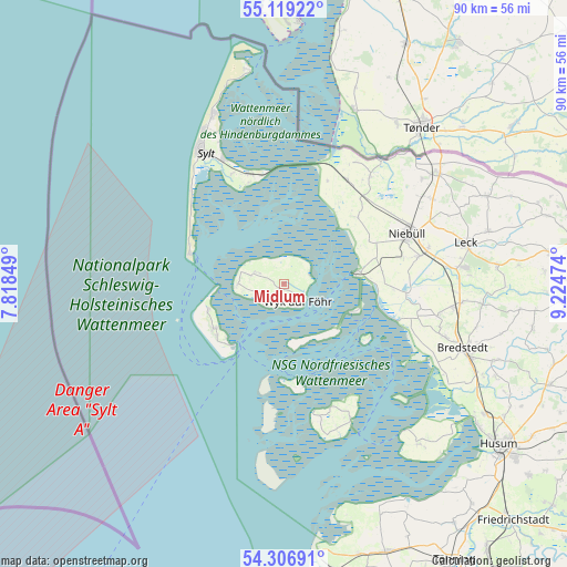
Midlum GPS coordinates[2]
54° 42' 54.36" North, 8° 31' 17.796" East
| Map corner | latitude | longitude |
|---|---|---|
| Upper-left | 55.11922°, | 7.81849° |
| Center: | 54.7151°, | 8.52161° |
| Lower-right: | 54.30691°, | 9.22474° |
| Map W x H: | 90.3×90.3 km | = 56.1×56.1mi |
| max Lat: | 55.01917° ⇑0.7% North |
| Midlum: | 54.7151° |
| min Lat: | ⇓99.3% South 47.40724° |
| min Long | Midlum | max Long |
| 5.92978° | 8.52161° | 14.98853° |
| W 29.1%⇐ | ⇒70.9% E |
Elevation
Elevation of Midlum is 6 m = 20 ft, and this is 243.1 m = 798 ft below average elevation for this country.
| Max E: |
1256 m = 4121 ft | 96.2% |
| Avg. | 249.1 m = 817 ft | |
| Midlum | 6 m = 20 ft | |
Min E: |
-5 m = -16 ft | 3.8% |
See also: Germany elevation on elevation.city.
Geographical zone
Midlum is located in North temperate zone (between Tropic of Cancer and the Arctic Circle). Distance of this North polar circle is 1317.4 km =818.6 mi to North.| Distance of | km | miles | from Midlum |
|---|---|---|---|
| North Pole | 3923.3 | 2437.8 | to North |
| Arctic Circle | 1317.4 | 818.6 | to North |
| Tropic Cancer | 3477.8 | 2161 | to South |
| Equator | 6083.7 | 3780.2 | to South |


Nearby cities:
15 places around Midlum: (largest is in red/bold)
• Alkersum
1.1 km =0.7 mi,  225°
225°
• Borgsum
4.4 km =2.7 mi,  248°
248°
• Dagebüll
11.6 km =7.2 mi,  82°
82°
• Dunsum
6.5 km =4 mi,  286°
286°
• Langeneß
9.4 km =5.8 mi,  151°
151°
• Nebel
12.9 km =8 mi,  236°
236°
• Nieblum
3.2 km =2 mi,  217°
217°
• Norddorf
12.7 km =7.9 mi, 252°
• Oevenum
0.8 km =0.5 mi,  129°
129°
• Oldsum
5.2 km =3.2 mi, 289°
• Süderende
5.5 km =3.4 mi,  282°
282°
• Utersum
7.4 km =4.6 mi,  269°
269°
• Witsum
5.5 km =3.4 mi, 251°
• Wrixum
2.4 km =1.5 mi, 134°
• Wyk auf Föhr
3.9 km =2.4 mi, 132°
Sources, notices
• [Note1] Compared only with cities in Germany existing in our database
• [Src1] Map data: © OpenStreetMap contributors (CC-BY-SA)
• [Src2] Other city data from geonames.org with taken over terms of usage.
• [Src3] Geographical zone / Annual Mean Temperature by Robert A. Rohde @ Wikipedia
