Greven geodata
Greven (Mecklenburg-Vorpommern) is a populated place; located in Germany in Europe/Berlin (GMT+2) time zone. With population of 826 people, there are 7794 cities with bigger population in this country. Compared to other cities in Germany, 85.4% of cities are located further ↓South; 81.5% of cities are located further ←West and 75.3% of cities have higher elevation than Greven. Note1
Administrative division(s):
- Level 1: Mecklenburg-Vorpommern
- Level 3: Ludwigslust-Parchim
- Level 4: Granzin


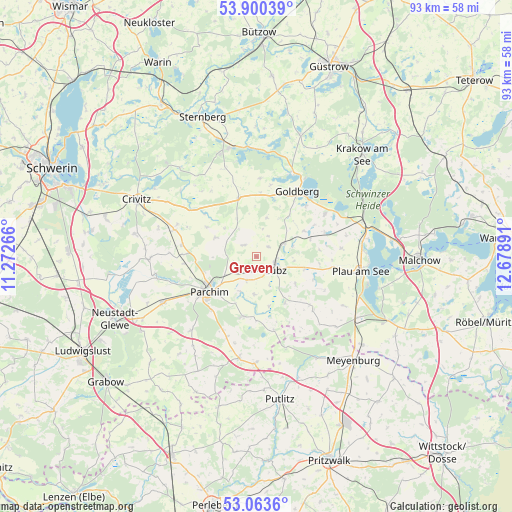
Greven GPS coordinates[2]
53° 29' 2.616" North, 11° 58' 32.808" East
| Map corner | latitude | longitude |
|---|---|---|
| Upper-left | 53.90039°, | 11.27266° |
| Center: | 53.48406°, | 11.97578° |
| Lower-right: | 53.0636°, | 12.67891° |
| Map W x H: | 93×93 km | = 57.8×57.8mi |
| max Lat: | 55.01917° ⇑14.6% North |
| Greven: | 53.48406° |
| min Lat: | ⇓85.4% South 47.40724° |
| min Long | Greven | max Long |
| 5.92978° | 11.97578° | 14.98853° |
| W 81.5%⇐ | ⇒18.5% E |
Elevation
Elevation of Greven is 62 m = 203 ft, and this is 187.1 m = 614 ft below average elevation for this country.
| Max E: |
1256 m = 4121 ft | 75.3% |
| Avg. | 249.1 m = 817 ft | |
| Greven | 62 m = 203 ft | |
Min E: |
-5 m = -16 ft | 24.7% |
See also: Germany elevation on elevation.city.
Geographical zone
Greven is located in North temperate zone (between Tropic of Cancer and the Arctic Circle). Distance of this North polar circle is 1454.3 km =903.7 mi to North.| Distance of | km | miles | from Greven |
|---|---|---|---|
| North Pole | 4060.2 | 2522.9 | to North |
| Arctic Circle | 1454.3 | 903.7 | to North |
| Tropic Cancer | 3341 | 2076 | to South |
| Equator | 5946.9 | 3695.2 | to South |


Nearby cities:
15 places around Greven: (largest is in red/bold)
• Diestelow
9.5 km =5.9 mi,  39°
39°
• Gallin
10.2 km =6.3 mi,  73°
73°
• Grambow
8.2 km =5.1 mi,  31°
31°
• Granzin
3 km =1.9 mi,  314°
314°
• Grebbin
8.2 km =5.1 mi,  294°
294°
• Lübz
4.3 km =2.7 mi,  124°
124°
• Mestlin
11.2 km =7 mi,  343°
343°
• Neuburg
9.4 km =5.8 mi,  204°
204°
• Parchim
10.6 km =6.6 mi,  232°
232°
• Passow
5.7 km =3.5 mi,  63°
63°
• Rom
4.7 km =2.9 mi, 202°
• Siggelkow
11 km =6.8 mi,  193°
193°
• Techentin
11.5 km =7.1 mi,  3°
3°
• Werder
2.8 km =1.7 mi,  48°
48°
• Zölkow
13.5 km =8.4 mi, 310°
Sources, notices
• [Note1] Compared only with cities in Germany existing in our database
• [Src1] Map data: © OpenStreetMap contributors (CC-BY-SA)
• [Src2] Other city data from geonames.org with taken over terms of usage.
• [Src3] Geographical zone / Annual Mean Temperature by Robert A. Rohde @ Wikipedia
