Mestlin geodata
Mestlin (Mecklenburg-Vorpommern) is a populated place; located in Germany in Europe/Berlin (GMT+2) time zone. With population of 999 people, there are 7188 cities with bigger population in this country. Compared to other cities in Germany, 86.7% of cities are located further ↓South; 80.7% of cities are located further ←West and 75% of cities have higher elevation than Mestlin. Note1
Administrative division(s):
- Level 1: Mecklenburg-Vorpommern
- Level 3: Ludwigslust-Parchim
- Level 4: Mestlin


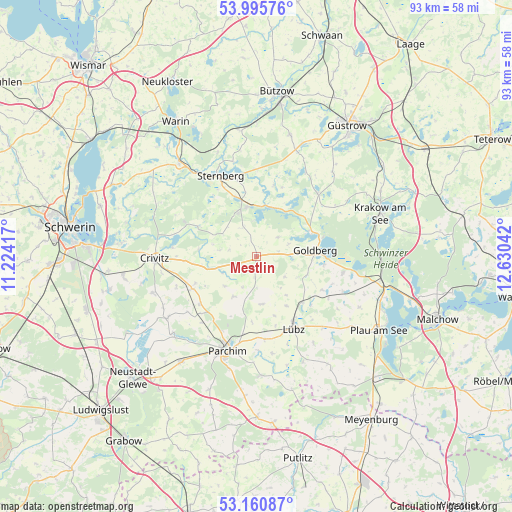
Mestlin GPS coordinates[2]
53° 34' 49.368" North, 11° 55' 38.244" East
| Map corner | latitude | longitude |
|---|---|---|
| Upper-left | 53.99576°, | 11.22417° |
| Center: | 53.58038°, | 11.92729° |
| Lower-right: | 53.16087°, | 12.63042° |
| Map W x H: | 92.8×92.8 km | = 57.7×57.7mi |
| max Lat: | 55.01917° ⇑13.3% North |
| Mestlin: | 53.58038° |
| min Lat: | ⇓86.7% South 47.40724° |
| min Long | Mestlin | max Long |
| 5.92978° | 11.92729° | 14.98853° |
| W 80.7%⇐ | ⇒19.3% E |
Elevation
Elevation of Mestlin is 63 m = 207 ft, and this is 186.1 m = 611 ft below average elevation for this country.
| Max E: |
1256 m = 4121 ft | 75% |
| Avg. | 249.1 m = 817 ft | |
| Mestlin | 63 m = 207 ft | |
Min E: |
-5 m = -16 ft | 25% |
See also: Germany elevation on elevation.city.
Geographical zone
Mestlin is located in North temperate zone (between Tropic of Cancer and the Arctic Circle). Distance of this North polar circle is 1443.6 km =897 mi to North.| Distance of | km | miles | from Mestlin |
|---|---|---|---|
| North Pole | 4049.5 | 2516.2 | to North |
| Arctic Circle | 1443.6 | 897 | to North |
| Tropic Cancer | 3351.7 | 2082.6 | to South |
| Equator | 5957.6 | 3701.9 | to South |


Nearby cities:
15 places around Mestlin: (largest is in red/bold)
• Borkow
9.4 km =5.8 mi,  9°
9°
• Dabel
9.2 km =5.7 mi,  348°
348°
• Demen
11.9 km =7.4 mi,  297°
297°
• Diestelow
9.8 km =6.1 mi,  110°
110°
• Dobbertin
10.8 km =6.7 mi,  63°
63°
• Goldberg
10.7 km =6.6 mi,  84°
84°
• Grambow
8.4 km =5.2 mi,  116°
116°
• Granzin
8.7 km =5.4 mi,  173°
173°
• Grebbin
8.4 km =5.2 mi,  210°
210°
• Greven
11.2 km =7 mi,  163°
163°
• Hohen Pritz
5.9 km =3.7 mi,  336°
336°
• Passow
11.6 km =7.2 mi,  134°
134°
• Techentin
4.1 km =2.5 mi, 79°
• Werder
10.3 km =6.4 mi,  148°
148°
• Zölkow
7.3 km =4.5 mi,  254°
254°
Sources, notices
• [Note1] Compared only with cities in Germany existing in our database
• [Src1] Map data: © OpenStreetMap contributors (CC-BY-SA)
• [Src2] Other city data from geonames.org with taken over terms of usage.
• [Src3] Geographical zone / Annual Mean Temperature by Robert A. Rohde @ Wikipedia
