Gössenheim geodata
Gössenheim (Bavaria) is a seat of a fourth-order administrative division; located in Germany in Europe/Berlin (GMT+2) time zone. With population of 1,319 people, there are 6253 cities with bigger population in this country. Compared to other cities in Germany, 63.5% of cities are located further ↑North; 53.1% of cities are located further →East and 57.4% of cities have higher elevation than Gössenheim. Note1
Administrative division(s):
- Level 1: Bavaria
- Level 2: Regierungsbezirk Unterfranken
- Level 3: Landkreis Main-Spessart
- Level 4: Gössenheim


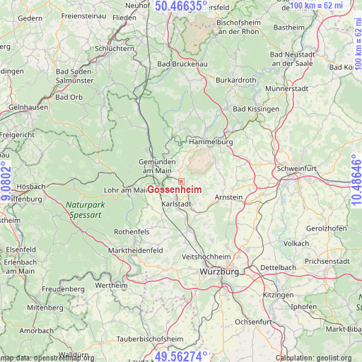
Gössenheim GPS coordinates[2]
50° 1' 0.012" North, 9° 46' 59.988" East
| Map corner | latitude | longitude |
|---|---|---|
| Upper-left | 50.46635°, | 9.0802° |
| Center: | 50.01667°, | 9.78333° |
| Lower-right: | 49.56274°, | 10.48646° |
| Map W x H: | 100.5×100.5 km | = 62.4×62.4mi |
| max Lat: | 55.01917° ⇑63.5% North |
| Gössenheim: | 50.01667° |
| min Lat: | ⇓36.5% South 47.40724° |
| min Long | Gössenheim | max Long |
| 5.92978° | 9.78333° | 14.98853° |
| W 46.9%⇐ | ⇒53.1% E |
Elevation
Elevation of Gössenheim is 172 m = 564 ft, and this is 77.1 m = 253 ft below average elevation for this country.
| Max E: |
1256 m = 4121 ft | 57.4% |
| Avg. | 249.1 m = 817 ft | |
| Gössenheim | 172 m = 564 ft | |
Min E: |
-5 m = -16 ft | 42.6% |
See also: Germany elevation on elevation.city.
Geographical zone
Gössenheim is located in North temperate zone (between Tropic of Cancer and the Arctic Circle). Distance of this North polar circle is 1839.8 km =1143.2 mi to North.| Distance of | km | miles | from Gössenheim |
|---|---|---|---|
| North Pole | 4445.7 | 2762.4 | to North |
| Arctic Circle | 1839.8 | 1143.2 | to North |
| Tropic Cancer | 2955.4 | 1836.4 | to South |
| Equator | 5561.3 | 3455.6 | to South |


Nearby cities:
15 places around Gössenheim: (largest is in red/bold)
• Erlenbach
10.8 km =6.7 mi,  246°
246°
• Eußenheim
3.9 km =2.4 mi,  151°
151°
• Gemünden am Main
6.6 km =4.1 mi,  303°
303°
• Gräfendorf
12.2 km =7.6 mi,  345°
345°
• Hammelburg
13.5 km =8.4 mi,  34°
34°
• Himmelstadt
10.4 km =6.5 mi,  172°
172°
• Karlstadt
6.3 km =3.9 mi,  187°
187°
• Karsbach
2.7 km =1.7 mi,  3°
3°
• Neuendorf
9.7 km =6 mi,  281°
281°
• Retzstadt
13.6 km =8.5 mi, 148°
• Rieneck
12.9 km =8 mi,  311°
311°
• Schönau
7.9 km =4.9 mi,  326°
326°
• Steinfeld
10.8 km =6.7 mi,  228°
228°
• Thüngen
10 km =6.2 mi, 147°
• Zellingen
13.5 km =8.4 mi, 169°
Sources, notices
• [Note1] Compared only with cities in Germany existing in our database
• [Src1] Map data: © OpenStreetMap contributors (CC-BY-SA)
• [Src2] Other city data from geonames.org with taken over terms of usage.
• [Src3] Geographical zone / Annual Mean Temperature by Robert A. Rohde @ Wikipedia
