Karlstadt geodata
Karlstadt (Bavaria) is a seat of a third-order administrative division; located in Germany in Europe/Berlin (GMT+2) time zone. With population of 15,272 people, there are 1048 cities with bigger population in this country. Compared to other cities in Germany, 64.9% of cities are located further ↑North; 53.2% of cities are located further →East and 57.4% of cities have higher elevation than Karlstadt. Note1
Administrative division(s):
- Level 1: Bavaria
- Level 2: Regierungsbezirk Unterfranken
- Level 3: Landkreis Main-Spessart
- Level 4: Karlstadt


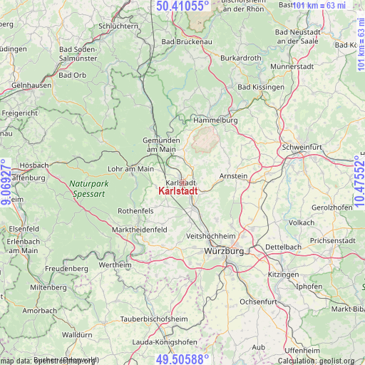
Karlstadt GPS coordinates[2]
49° 57' 37.224" North, 9° 46' 20.604" East
| Map corner | latitude | longitude |
|---|---|---|
| Upper-left | 50.41055°, | 9.06927° |
| Center: | 49.96034°, | 9.77239° |
| Lower-right: | 49.50588°, | 10.47552° |
| Map W x H: | 100.6×100.6 km | = 62.5×62.5mi |
| max Lat: | 55.01917° ⇑64.9% North |
| Karlstadt: | 49.96034° |
| min Lat: | ⇓35.1% South 47.40724° |
| min Long | Karlstadt | max Long |
| 5.92978° | 9.77239° | 14.98853° |
| W 46.8%⇐ | ⇒53.2% E |
Elevation
Elevation of Karlstadt is 172 m = 564 ft, and this is 77.1 m = 253 ft below average elevation for this country.
| Max E: |
1256 m = 4121 ft | 57.4% |
| Avg. | 249.1 m = 817 ft | |
| Karlstadt | 172 m = 564 ft | |
Min E: |
-5 m = -16 ft | 42.6% |
See also: Germany elevation on elevation.city.
Geographical zone
Karlstadt is located in North temperate zone (between Tropic of Cancer and the Arctic Circle). Distance of this North polar circle is 1846.1 km =1147.1 mi to North.| Distance of | km | miles | from Karlstadt |
|---|---|---|---|
| North Pole | 4452 | 2766.3 | to North |
| Arctic Circle | 1846.1 | 1147.1 | to North |
| Tropic Cancer | 2949.2 | 1832.5 | to South |
| Equator | 5555.1 | 3451.8 | to South |


Nearby cities:
15 places around Karlstadt: (largest is in red/bold)
• Birkenfeld
12.6 km =7.8 mi,  205°
205°
• Erlabrunn
12.3 km =7.6 mi,  155°
155°
• Erlenbach
9.4 km =5.8 mi,  282°
282°
• Eußenheim
3.9 km =2.4 mi,  42°
42°
• Gemünden am Main
11 km =6.8 mi,  334°
334°
• Gössenheim
6.3 km =3.9 mi,  7°
7°
• Himmelstadt
4.6 km =2.9 mi,  152°
152°
• Karsbach
9 km =5.6 mi, 5°
• Neuendorf
11.9 km =7.4 mi,  312°
312°
• Retzstadt
9.5 km =5.9 mi,  124°
124°
• Steinfeld
7.4 km =4.6 mi,  263°
263°
• Thüngen
6.5 km =4 mi,  108°
108°
• Thüngersheim
10.6 km =6.6 mi, 148°
• Urspringen
9.7 km =6 mi,  227°
227°
• Zellingen
7.7 km =4.8 mi, 155°
Sources, notices
• [Note1] Compared only with cities in Germany existing in our database
• [Src1] Map data: © OpenStreetMap contributors (CC-BY-SA)
• [Src2] Other city data from geonames.org with taken over terms of usage.
• [Src3] Geographical zone / Annual Mean Temperature by Robert A. Rohde @ Wikipedia
