Eußenheim geodata
Eußenheim (Bavaria) is a seat of a fourth-order administrative division; located in Germany in Europe/Berlin (GMT+2) time zone. With population of 3,302 people, there are 3753 cities with bigger population in this country. Compared to other cities in Germany, 64% of cities are located further ↑North; 52.6% of cities are located further →East and 55.8% of cities have higher elevation than Eußenheim. Note1
Administrative division(s):
- Level 1: Bavaria
- Level 2: Regierungsbezirk Unterfranken
- Level 3: Landkreis Main-Spessart
- Level 4: Eußenheim


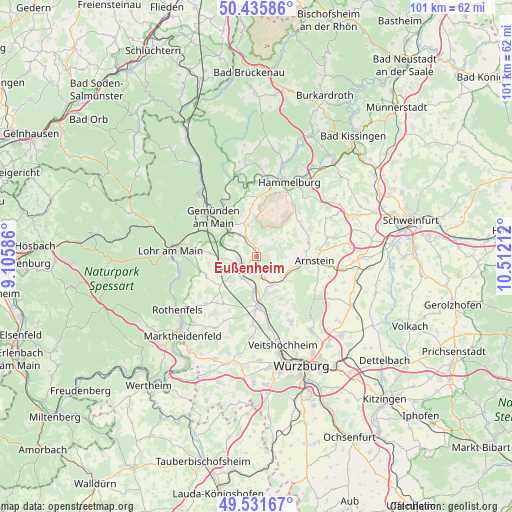
Eußenheim GPS coordinates[2]
49° 59' 9.204" North, 9° 48' 32.364" East
| Map corner | latitude | longitude |
|---|---|---|
| Upper-left | 50.43586°, | 9.10586° |
| Center: | 49.98589°, | 9.80899° |
| Lower-right: | 49.53167°, | 10.51212° |
| Map W x H: | 100.5×100.5 km | = 62.4×62.4mi |
| max Lat: | 55.01917° ⇑64% North |
| Eußenheim: | 49.98589° |
| min Lat: | ⇓36% South 47.40724° |
| min Long | Eußenheim | max Long |
| 5.92978° | 9.80899° | 14.98853° |
| W 47.4%⇐ | ⇒52.6% E |
Elevation
Elevation of Eußenheim is 183 m = 600 ft, and this is 66.1 m = 217 ft below average elevation for this country.
| Max E: |
1256 m = 4121 ft | 55.8% |
| Avg. | 249.1 m = 817 ft | |
| Eußenheim | 183 m = 600 ft | |
Min E: |
-5 m = -16 ft | 44.2% |
See also: Germany elevation on elevation.city.
Geographical zone
Eußenheim is located in North temperate zone (between Tropic of Cancer and the Arctic Circle). Distance of this North polar circle is 1843.3 km =1145.4 mi to North.| Distance of | km | miles | from Eußenheim |
|---|---|---|---|
| North Pole | 4449.2 | 2764.6 | to North |
| Arctic Circle | 1843.3 | 1145.4 | to North |
| Tropic Cancer | 2952 | 1834.3 | to South |
| Equator | 5557.9 | 3453.5 | to South |


Nearby cities:
15 places around Eußenheim: (largest is in red/bold)
• Arnstein
11.5 km =7.1 mi,  94°
94°
• Erlenbach
11.8 km =7.3 mi,  266°
266°
• Gemünden am Main
10.2 km =6.3 mi,  313°
313°
• Gössenheim
3.9 km =2.4 mi,  331°
331°
• Himmelstadt
6.9 km =4.3 mi,  184°
184°
• Karlstadt
3.9 km =2.4 mi,  222°
222°
• Karsbach
6.3 km =3.9 mi,  344°
344°
• Neuendorf
12.5 km =7.8 mi,  294°
294°
• Retzstadt
9.7 km =6 mi,  147°
147°
• Schönau
11.8 km =7.3 mi, 328°
• Steinfeld
10.6 km =6.6 mi,  249°
249°
• Thüngen
6.1 km =3.8 mi,  144°
144°
• Thüngersheim
12.3 km =7.6 mi,  166°
166°
• Urspringen
13.6 km =8.5 mi,  226°
226°
• Zellingen
9.9 km =6.2 mi, 176°
Sources, notices
• [Note1] Compared only with cities in Germany existing in our database
• [Src1] Map data: © OpenStreetMap contributors (CC-BY-SA)
• [Src2] Other city data from geonames.org with taken over terms of usage.
• [Src3] Geographical zone / Annual Mean Temperature by Robert A. Rohde @ Wikipedia
