Göritz geodata
Göritz (Brandenburg) is a seat of a fourth-order administrative division; located in Germany in Europe/Berlin (GMT+2) time zone. With population of 861 people, there are 7660 cities with bigger population in this country. Compared to other cities in Germany, 84.6% of cities are located further ↓South; 97.6% of cities are located further ←West and 84.1% of cities have higher elevation than Göritz. Note1


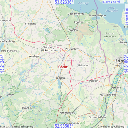
Göritz GPS coordinates[2]
53° 24' 22.536" North, 13° 54' 56.016" East
| Map corner | latitude | longitude |
|---|---|---|
| Upper-left | 53.82336°, | 13.21244° |
| Center: | 53.40626°, | 13.91556° |
| Lower-right: | 52.98503°, | 14.61869° |
| Map W x H: | 93.2×93.2 km | = 57.9×57.9mi |
| max Lat: | 55.01917° ⇑15.4% North |
| Göritz: | 53.40626° |
| min Lat: | ⇓84.6% South 47.40724° |
| min Long | Göritz | max Long |
| 5.92978° | 13.91556° | 14.98853° |
| W 97.6%⇐ | ⇒2.4% E |
Elevation
Elevation of Göritz is 37 m = 121 ft, and this is 212.1 m = 696 ft below average elevation for this country.
| Max E: |
1256 m = 4121 ft | 84.1% |
| Avg. | 249.1 m = 817 ft | |
| Göritz | 37 m = 121 ft | |
Min E: |
-5 m = -16 ft | 15.9% |
See also: Germany elevation on elevation.city.
Geographical zone
Göritz is located in North temperate zone (between Tropic of Cancer and the Arctic Circle). Distance of this North polar circle is 1463 km =909.1 mi to North.| Distance of | km | miles | from Göritz |
|---|---|---|---|
| North Pole | 4068.8 | 2528.2 | to North |
| Arctic Circle | 1463 | 909.1 | to North |
| Tropic Cancer | 3332.3 | 2070.6 | to South |
| Equator | 5938.2 | 3689.8 | to South |


Nearby cities:
15 places around Göritz: (largest is in red/bold)
• Brüssow
13.9 km =8.6 mi,  92°
92°
• Gramzow
22.4 km =13.9 mi,  164°
164°
• Grünow
10.2 km =6.3 mi,  167°
167°
• Hammer
22.1 km =13.7 mi,  11°
11°
• Jatznick
19.3 km =12 mi,  4°
4°
• Pasewalk
12.2 km =7.6 mi,  23°
23°
• Prenzlau
10.6 km =6.6 mi,  199°
199°
• Rollwitz
8.5 km =5.3 mi,  28°
28°
• Schenkenberg
5 km =3.1 mi,  152°
152°
• Schönfeld
4.7 km =2.9 mi,  80°
80°
• Schönwalde
15.3 km =9.5 mi,  357°
357°
• Strasburg
16.2 km =10.1 mi,  315°
315°
• Viereck
17.9 km =11.1 mi, 27°
• Woldegk
22.8 km =14.2 mi,  285°
285°
• Zerrenthin
15.1 km =9.4 mi,  49°
49°
Sources, notices
• [Note1] Compared only with cities in Germany existing in our database
• [Src1] Map data: © OpenStreetMap contributors (CC-BY-SA)
• [Src2] Other city data from geonames.org with taken over terms of usage.
• [Src3] Geographical zone / Annual Mean Temperature by Robert A. Rohde @ Wikipedia
