Gramzow geodata
Gramzow (Brandenburg) is a seat of a fourth-order administrative division; located in Germany in Europe/Berlin (GMT+2) time zone. With population of 2,113 people, there are 4914 cities with bigger population in this country. Compared to other cities in Germany, 82.9% of cities are located further ↓South; 98% of cities are located further ←West and 75% of cities have higher elevation than Gramzow. Note1


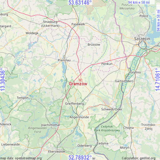
Gramzow GPS coordinates[2]
53° 12' 44.856" North, 14° 0' 26.928" East
| Map corner | latitude | longitude |
|---|---|---|
| Upper-left | 53.63146°, | 13.30436° |
| Center: | 53.21246°, | 14.00748° |
| Lower-right: | 52.78932°, | 14.71061° |
| Map W x H: | 93.6×93.6 km | = 58.2×58.2mi |
| max Lat: | 55.01917° ⇑17.1% North |
| Gramzow: | 53.21246° |
| min Lat: | ⇓82.9% South 47.40724° |
| min Long | Gramzow | max Long |
| 5.92978° | 14.00748° | 14.98853° |
| W 98%⇐ | ⇒2% E |
Elevation
Elevation of Gramzow is 63 m = 207 ft, and this is 186.1 m = 611 ft below average elevation for this country.
| Max E: |
1256 m = 4121 ft | 75% |
| Avg. | 249.1 m = 817 ft | |
| Gramzow | 63 m = 207 ft | |
Min E: |
-5 m = -16 ft | 25% |
See also: Germany elevation on elevation.city.
Geographical zone
Gramzow is located in North temperate zone (between Tropic of Cancer and the Arctic Circle). Distance of this North polar circle is 1484.5 km =922.4 mi to North.| Distance of | km | miles | from Gramzow |
|---|---|---|---|
| North Pole | 4090.4 | 2541.7 | to North |
| Arctic Circle | 1484.5 | 922.4 | to North |
| Tropic Cancer | 3310.8 | 2057.2 | to South |
| Equator | 5916.7 | 3676.5 | to South |


Nearby cities:
15 places around Gramzow: (largest is in red/bold)
• Angermünde
22 km =13.7 mi,  181°
181°
• Brüssow
22.2 km =13.8 mi,  20°
20°
• Casekow
13.4 km =8.3 mi,  90°
90°
• Gerswalde
17.9 km =11.1 mi,  254°
254°
• Grünow
12.2 km =7.6 mi,  341°
341°
• Göritz
22.4 km =13.9 mi, 344°
• Krackow
22.5 km =14 mi,  49°
49°
• Mittenwalde
22.9 km =14.2 mi,  261°
261°
• Passow
10.5 km =6.5 mi,  137°
137°
• Penkun
17.9 km =11.1 mi,  58°
58°
• Pinnow
17.5 km =10.9 mi,  162°
162°
• Prenzlau
15 km =9.3 mi,  320°
320°
• Schenkenberg
17.6 km =10.9 mi,  347°
347°
• Schönfeld
22.4 km =13.9 mi,  356°
356°
• Zichow
3.3 km =2.1 mi, 141°
Sources, notices
• [Note1] Compared only with cities in Germany existing in our database
• [Src1] Map data: © OpenStreetMap contributors (CC-BY-SA)
• [Src2] Other city data from geonames.org with taken over terms of usage.
• [Src3] Geographical zone / Annual Mean Temperature by Robert A. Rohde @ Wikipedia
