Prenzlau geodata
Prenzlau (Brandenburg) is a seat of a third-order administrative division; located in Germany in Europe/Berlin (GMT+2) time zone. With population of 20,899 people, there are 731 cities with bigger population in this country. Compared to other cities in Germany, 83.8% of cities are located further ↓South; 97.4% of cities are located further ←West and 86.3% of cities have higher elevation than Prenzlau. Note1


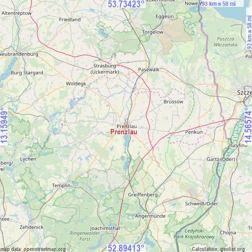
Prenzlau GPS coordinates[2]
53° 18' 58.5" North, 13° 51' 45.396" East
| Map corner | latitude | longitude |
|---|---|---|
| Upper-left | 53.73423°, | 13.15949° |
| Center: | 53.31625°, | 13.86261° |
| Lower-right: | 52.89413°, | 14.56574° |
| Map W x H: | 93.4×93.4 km | = 58×58mi |
| max Lat: | 55.01917° ⇑16.2% North |
| Prenzlau: | 53.31625° |
| min Lat: | ⇓83.8% South 47.40724° |
| min Long | Prenzlau | max Long |
| 5.92978° | 13.86261° | 14.98853° |
| W 97.4%⇐ | ⇒2.6% E |
Elevation
Elevation of Prenzlau is 32 m = 105 ft, and this is 217.1 m = 712 ft below average elevation for this country.
| Max E: |
1256 m = 4121 ft | 86.3% |
| Avg. | 249.1 m = 817 ft | |
| Prenzlau | 32 m = 105 ft | |
Min E: |
-5 m = -16 ft | 13.7% |
See also: Germany elevation on elevation.city.
Geographical zone
Prenzlau is located in North temperate zone (between Tropic of Cancer and the Arctic Circle). Distance of this North polar circle is 1473 km =915.3 mi to North.| Distance of | km | miles | from Prenzlau |
|---|---|---|---|
| North Pole | 4078.9 | 2534.5 | to North |
| Arctic Circle | 1473 | 915.3 | to North |
| Tropic Cancer | 3322.3 | 2064.4 | to South |
| Equator | 5928.2 | 3683.6 | to South |


Nearby cities:
15 places around Prenzlau: (largest is in red/bold)
• Brüssow
19.7 km =12.2 mi,  61°
61°
• Gerswalde
18 km =11.2 mi,  205°
205°
• Gramzow
15 km =9.3 mi,  140°
140°
• Grünow
5.8 km =3.6 mi,  89°
89°
• Göritz
10.6 km =6.6 mi,  19°
19°
• Mittenwalde
19.7 km =12.2 mi,  221°
221°
• Pasewalk
22.8 km =14.2 mi, 21°
• Penkun
24.9 km =15.5 mi, 94°
• Rollwitz
19.1 km =11.9 mi, 23°
• Schenkenberg
8.1 km =5 mi,  45°
45°
• Schönfeld
13.6 km =8.5 mi,  37°
37°
• Strasburg
22.9 km =14.2 mi,  340°
340°
• Woldegk
24.5 km =15.2 mi,  310°
310°
• Zerrenthin
24.8 km =15.4 mi, 37°
• Zichow
18.3 km =11.4 mi, 140°
Sources, notices
• [Note1] Compared only with cities in Germany existing in our database
• [Src1] Map data: © OpenStreetMap contributors (CC-BY-SA)
• [Src2] Other city data from geonames.org with taken over terms of usage.
• [Src3] Geographical zone / Annual Mean Temperature by Robert A. Rohde @ Wikipedia
