Göllheim geodata
Göllheim (Rheinland-Pfalz) is a seat of a fourth-order administrative division; located in Germany in Europe/Berlin (GMT+2) time zone. With population of 3,773 people, there are 3424 cities with bigger population in this country. Compared to other cities in Germany, 73.9% of cities are located further ↑North; 76.2% of cities are located further →East and 53.1% of cities have lower elevation than Göllheim. Note1


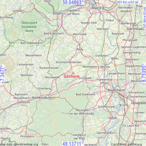
Göllheim GPS coordinates[2]
49° 35' 42" North, 8° 3' 2.988" East
| Map corner | latitude | longitude |
|---|---|---|
| Upper-left | 50.04863°, | 7.3477° |
| Center: | 49.595°, | 8.05083° |
| Lower-right: | 49.13711°, | 8.75395° |
| Map W x H: | 101.4×101.3 km | = 63×62.9mi |
| max Lat: | 55.01917° ⇑73.9% North |
| Göllheim: | 49.595° |
| min Lat: | ⇓26.1% South 47.40724° |
| min Long | Göllheim | max Long |
| 5.92978° | 8.05083° | 14.98853° |
| W 23.8%⇐ | ⇒76.2% E |
Elevation
Elevation of Göllheim is 247 m = 810 ft, and this is 2.1 m = 7 ft below average elevation for this country.
| Max E: |
1256 m = 4121 ft | 46.9% |
| Avg. | 249.1 m = 817 ft | |
| Göllheim | 247 m = 810 ft | |
Min E: |
-5 m = -16 ft | 53.1% |
See also: Germany elevation on elevation.city.
Geographical zone
Göllheim is located in North temperate zone (between Tropic of Cancer and the Arctic Circle). Distance of this North polar circle is 1886.7 km =1172.3 mi to North.| Distance of | km | miles | from Göllheim |
|---|---|---|---|
| North Pole | 4492.6 | 2791.6 | to North |
| Arctic Circle | 1886.7 | 1172.3 | to North |
| Tropic Cancer | 2908.5 | 1807.3 | to South |
| Equator | 5514.4 | 3426.5 | to South |


Nearby cities:
15 places around Göllheim: (largest is in red/bold)
• Bennhausen
5.4 km =3.4 mi,  296°
296°
• Biedesheim
4.2 km =2.6 mi,  74°
74°
• Bolanden
5.7 km =3.5 mi,  330°
330°
• Dreisen
3 km =1.9 mi,  287°
287°
• Ebertsheim
5.1 km =3.2 mi,  125°
125°
• Eisenberg
4.3 km =2.7 mi,  159°
159°
• Kerzenheim
2.2 km =1.4 mi, 162°
• Lautersheim
3.5 km =2.2 mi,  104°
104°
• Marnheim
4.3 km =2.7 mi,  349°
349°
• Ottersheim
5.4 km =3.4 mi,  50°
50°
• Quirnheim
5.6 km =3.5 mi, 102°
• Rodenbach
4.7 km =2.9 mi,  119°
119°
• Rüssingen
3.6 km =2.2 mi, 49°
• Standenbühl
4.9 km =3 mi,  276°
276°
• Weitersweiler
4.4 km =2.7 mi, 303°
Sources, notices
• [Note1] Compared only with cities in Germany existing in our database
• [Src1] Map data: © OpenStreetMap contributors (CC-BY-SA)
• [Src2] Other city data from geonames.org with taken over terms of usage.
• [Src3] Geographical zone / Annual Mean Temperature by Robert A. Rohde @ Wikipedia
