Eisenberg geodata
Eisenberg (Rheinland-Pfalz) is a populated place; located in Germany in Europe/Berlin (GMT+2) time zone. With population of 10,006 people, there are 1636 cities with bigger population in this country. Compared to other cities in Germany, 74.6% of cities are located further ↑North; 75.9% of cities are located further →East and 55% of cities have higher elevation than Eisenberg. Note1
Administrative division(s):
- Level 1: Rheinland-Pfalz
- Level 3: Donnersbergkreis
- Level 4: Eisenberg (Pfalz)


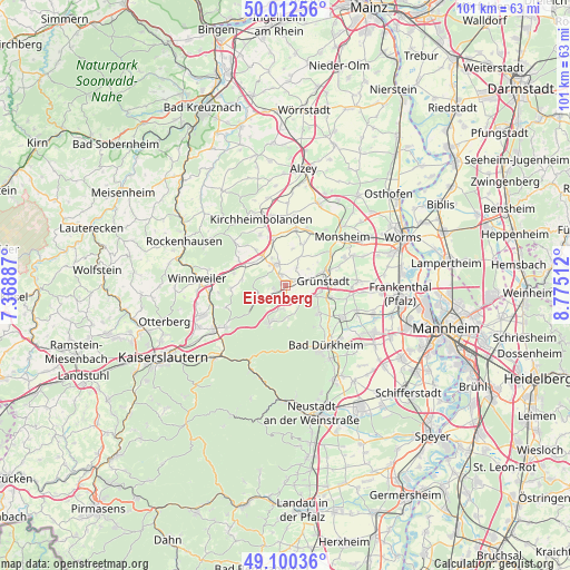
Eisenberg GPS coordinates[2]
49° 33' 30.924" North, 8° 4' 19.164" East
| Map corner | latitude | longitude |
|---|---|---|
| Upper-left | 50.01256°, | 7.36887° |
| Center: | 49.55859°, | 8.07199° |
| Lower-right: | 49.10036°, | 8.77512° |
| Map W x H: | 101.4×101.4 km | = 63×63mi |
| max Lat: | 55.01917° ⇑74.6% North |
| Eisenberg: | 49.55859° |
| min Lat: | ⇓25.4% South 47.40724° |
| min Long | Eisenberg | max Long |
| 5.92978° | 8.07199° | 14.98853° |
| W 24.1%⇐ | ⇒75.9% E |
Elevation
Elevation of Eisenberg is 188 m = 617 ft, and this is 61.1 m = 200 ft below average elevation for this country.
| Max E: |
1256 m = 4121 ft | 55% |
| Avg. | 249.1 m = 817 ft | |
| Eisenberg | 188 m = 617 ft | |
Min E: |
-5 m = -16 ft | 45% |
See also: Germany elevation on elevation.city.
Geographical zone
Eisenberg is located in North temperate zone (between Tropic of Cancer and the Arctic Circle). Distance of this North polar circle is 1890.8 km =1174.9 mi to North.| Distance of | km | miles | from Eisenberg |
|---|---|---|---|
| North Pole | 4496.7 | 2794.1 | to North |
| Arctic Circle | 1890.8 | 1174.9 | to North |
| Tropic Cancer | 2904.5 | 1804.8 | to South |
| Equator | 5510.4 | 3424 | to South |


Nearby cities:
15 places around Eisenberg: (largest is in red/bold)
• Altleiningen
5.7 km =3.5 mi,  179°
179°
• Biedesheim
5.8 km =3.6 mi,  26°
26°
• Ebertsheim
2.9 km =1.8 mi,  67°
67°
• Göllheim
4.3 km =2.7 mi,  339°
339°
• Hettenleidelheim
2.6 km =1.6 mi, 177°
• Kerzenheim
2.2 km =1.4 mi, 335°
• Kleinkarlbach
6 km =3.7 mi,  111°
111°
• Lautersheim
3.7 km =2.3 mi, 30°
• Mertesheim
4.8 km =3 mi, 72°
• Neuleiningen
5.2 km =3.2 mi, 111°
• Quirnheim
4.9 km =3 mi,  53°
53°
• Ramsen
4.9 km =3 mi,  240°
240°
• Rodenbach
3.1 km =1.9 mi,  55°
55°
• Tiefenthal
3.2 km =2 mi,  133°
133°
• Wattenheim
4.2 km =2.6 mi,  190°
190°
Sources, notices
• [Note1] Compared only with cities in Germany existing in our database
• [Src1] Map data: © OpenStreetMap contributors (CC-BY-SA)
• [Src2] Other city data from geonames.org with taken over terms of usage.
• [Src3] Geographical zone / Annual Mean Temperature by Robert A. Rohde @ Wikipedia
