Kerzenheim geodata
Kerzenheim (Rheinland-Pfalz) is a seat of a fourth-order administrative division; located in Germany in Europe/Berlin (GMT+2) time zone. With population of 2,271 people, there are 4717 cities with bigger population in this country. Compared to other cities in Germany, 74.3% of cities are located further ↑North; 76.1% of cities are located further →East and 55% of cities have lower elevation than Kerzenheim. Note1


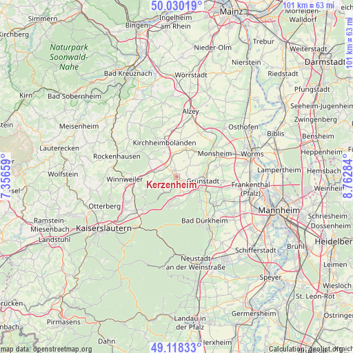
Kerzenheim GPS coordinates[2]
49° 34' 35.004" North, 8° 3' 34.992" East
| Map corner | latitude | longitude |
|---|---|---|
| Upper-left | 50.03019°, | 7.35659° |
| Center: | 49.57639°, | 8.05972° |
| Lower-right: | 49.11833°, | 8.76284° |
| Map W x H: | 101.4×101.4 km | = 63×63mi |
| max Lat: | 55.01917° ⇑74.3% North |
| Kerzenheim: | 49.57639° |
| min Lat: | ⇓25.7% South 47.40724° |
| min Long | Kerzenheim | max Long |
| 5.92978° | 8.05972° | 14.98853° |
| W 23.9%⇐ | ⇒76.1% E |
Elevation
Elevation of Kerzenheim is 258 m = 846 ft, and this is 8.9 m = 29 ft above average elevation for this country.
| Max E: |
1256 m = 4121 ft | 45% |
| Kerzenheim | 258 m 846 ft | |
| Avg. | 249.1 m = 817 ft | |
Min E: |
-5 m = -16 ft | 55% |
See also: Germany elevation on elevation.city.
Geographical zone
Kerzenheim is located in North temperate zone (between Tropic of Cancer and the Arctic Circle). Distance of this North polar circle is 1888.8 km =1173.6 mi to North.| Distance of | km | miles | from Kerzenheim |
|---|---|---|---|
| North Pole | 4494.7 | 2792.9 | to North |
| Arctic Circle | 1888.8 | 1173.6 | to North |
| Tropic Cancer | 2906.5 | 1806 | to South |
| Equator | 5512.4 | 3425.2 | to South |


Nearby cities:
15 places around Kerzenheim: (largest is in red/bold)
• Biedesheim
4.7 km =2.9 mi,  47°
47°
• Dreisen
4.6 km =2.9 mi,  310°
310°
• Ebertsheim
3.6 km =2.2 mi,  104°
104°
• Eisenberg
2.2 km =1.4 mi,  155°
155°
• Göllheim
2.2 km =1.4 mi,  342°
342°
• Hettenleidelheim
4.6 km =2.9 mi,  167°
167°
• Lautersheim
3 km =1.9 mi,  66°
66°
• Mertesheim
5.5 km =3.4 mi, 95°
• Quirnheim
4.9 km =3 mi,  79°
79°
• Ramsen
5.5 km =3.4 mi,  217°
217°
• Rodenbach
3.4 km =2.1 mi,  94°
94°
• Rüssingen
4.8 km =3 mi,  25°
25°
• Standenbühl
6.1 km =3.8 mi,  295°
295°
• Tiefenthal
5.3 km =3.3 mi,  142°
142°
• Wattenheim
6.1 km =3.8 mi,  178°
178°
Sources, notices
• [Note1] Compared only with cities in Germany existing in our database
• [Src1] Map data: © OpenStreetMap contributors (CC-BY-SA)
• [Src2] Other city data from geonames.org with taken over terms of usage.
• [Src3] Geographical zone / Annual Mean Temperature by Robert A. Rohde @ Wikipedia
