Gindorf geodata
Gindorf (Rheinland-Pfalz) is a seat of a fourth-order administrative division; located in Germany in Europe/Berlin (GMT+2) time zone. With population of 308 people, there are 10026 cities with bigger population in this country. Compared to other cities in Germany, 63.5% of cities are located further ↑North; 96.7% of cities are located further →East and 69.7% of cities have lower elevation than Gindorf. Note1
Administrative division(s):
- Level 1: Rheinland-Pfalz
- Level 3: Eifelkreis Bitburg-Prüm
- Level 4: Gindorf


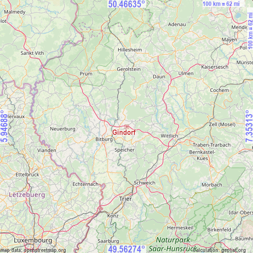
Gindorf GPS coordinates[2]
50° 1' 0.012" North, 6° 39' 0" East
| Map corner | latitude | longitude |
|---|---|---|
| Upper-left | 50.46635°, | 5.94688° |
| Center: | 50.01667°, | 6.65° |
| Lower-right: | 49.56274°, | 7.35313° |
| Map W x H: | 100.5×100.5 km | = 62.4×62.4mi |
| max Lat: | 55.01917° ⇑63.5% North |
| Gindorf: | 50.01667° |
| min Lat: | ⇓36.5% South 47.40724° |
| min Long | Gindorf | max Long |
| 5.92978° | 6.65° | 14.98853° |
| W 3.3%⇐ | ⇒96.7% E |
Elevation
Elevation of Gindorf is 356 m = 1168 ft, and this is 106.9 m = 351 ft above average elevation for this country.
| Max E: |
1256 m = 4121 ft | 30.3% |
| Gindorf | 356 m 1168 ft | |
| Avg. | 249.1 m = 817 ft | |
Min E: |
-5 m = -16 ft | 69.7% |
See also: Germany elevation on elevation.city.
Geographical zone
Gindorf is located in North temperate zone (between Tropic of Cancer and the Arctic Circle). Distance of this North polar circle is 1839.8 km =1143.2 mi to North.| Distance of | km | miles | from Gindorf |
|---|---|---|---|
| North Pole | 4445.7 | 2762.4 | to North |
| Arctic Circle | 1839.8 | 1143.2 | to North |
| Tropic Cancer | 2955.4 | 1836.4 | to South |
| Equator | 5561.3 | 3455.6 | to South |


Nearby cities:
15 places around Gindorf: (largest is in red/bold)
• Badem
3 km =1.9 mi,  232°
232°
• Dudeldorf
4.7 km =2.9 mi,  191°
191°
• Eisenschmitt
6 km =3.7 mi,  59°
59°
• Gondorf
6 km =3.7 mi,  203°
203°
• Gransdorf
2.4 km =1.5 mi,  90°
90°
• Kyllburg
4.6 km =2.9 mi,  301°
301°
• Kyllburgweiler
4.4 km =2.7 mi,  327°
327°
• Metterich
5.9 km =3.7 mi, 226°
• Oberkail
3 km =1.9 mi,  52°
52°
• Orsfeld
3 km =1.9 mi,  307°
307°
• Schwarzenborn
5.1 km =3.2 mi,  68°
68°
• Seinsfeld
3.7 km =2.3 mi,  0°
0°
• Spangdahlem
4.4 km =2.7 mi,  147°
147°
• Steinborn
5.7 km =3.5 mi,  347°
347°
• Wilsecker
4.8 km =3 mi,  270°
270°
Sources, notices
• [Note1] Compared only with cities in Germany existing in our database
• [Src1] Map data: © OpenStreetMap contributors (CC-BY-SA)
• [Src2] Other city data from geonames.org with taken over terms of usage.
• [Src3] Geographical zone / Annual Mean Temperature by Robert A. Rohde @ Wikipedia
