Gondorf geodata
Gondorf (Rheinland-Pfalz) is a seat of a fourth-order administrative division; located in Germany in Europe/Berlin (GMT+2) time zone. With population of 301 people, there are 10045 cities with bigger population in this country. Compared to other cities in Germany, 64.8% of cities are located further ↑North; 96.9% of cities are located further →East and 60% of cities have lower elevation than Gondorf. Note1
Administrative division(s):
- Level 1: Rheinland-Pfalz
- Level 3: Eifelkreis Bitburg-Prüm
- Level 4: Gondorf


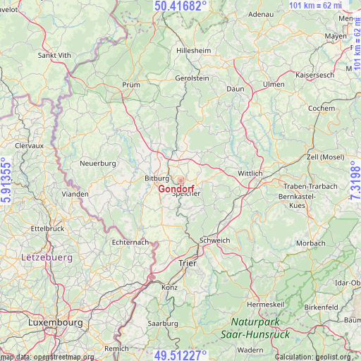
Gondorf GPS coordinates[2]
49° 58' 0.012" North, 6° 37' 0.012" East
| Map corner | latitude | longitude |
|---|---|---|
| Upper-left | 50.41682°, | 5.91355° |
| Center: | 49.96667°, | 6.61667° |
| Lower-right: | 49.51227°, | 7.3198° |
| Map W x H: | 100.6×100.6 km | = 62.5×62.5mi |
| max Lat: | 55.01917° ⇑64.8% North |
| Gondorf: | 49.96667° |
| min Lat: | ⇓35.2% South 47.40724° |
| min Long | Gondorf | max Long |
| 5.92978° | 6.61667° | 14.98853° |
| W 3.1%⇐ | ⇒96.9% E |
Elevation
Elevation of Gondorf is 290 m = 951 ft, and this is 40.9 m = 134 ft above average elevation for this country.
| Max E: |
1256 m = 4121 ft | 40% |
| Gondorf | 290 m 951 ft | |
| Avg. | 249.1 m = 817 ft | |
Min E: |
-5 m = -16 ft | 60% |
See also: Germany elevation on elevation.city.
Geographical zone
Gondorf is located in North temperate zone (between Tropic of Cancer and the Arctic Circle). Distance of this North polar circle is 1845.4 km =1146.7 mi to North.| Distance of | km | miles | from Gondorf |
|---|---|---|---|
| North Pole | 4451.3 | 2765.9 | to North |
| Arctic Circle | 1845.4 | 1146.7 | to North |
| Tropic Cancer | 2949.9 | 1833 | to South |
| Equator | 5555.8 | 3452.2 | to South |


Nearby cities:
15 places around Gondorf: (largest is in red/bold)
• Badem
3.7 km =2.3 mi,  0°
0°
• Beilingen
4 km =2.5 mi,  117°
117°
• Bitburg
6.4 km =4 mi,  271°
271°
• Dahlem
5.7 km =3.5 mi,  192°
192°
• Dudeldorf
1.7 km =1.1 mi,  57°
57°
• Gindorf
6 km =3.7 mi,  23°
23°
• Herforst
6.2 km =3.9 mi,  107°
107°
• Metterich
2.4 km =1.5 mi,  307°
307°
• Philippsheim
2.2 km =1.4 mi,  147°
147°
• Röhl
4.4 km =2.7 mi,  212°
212°
• Scharfbillig
5.8 km =3.6 mi,  229°
229°
• Spangdahlem
5.1 km =3.2 mi,  68°
68°
• Speicher
3.9 km =2.4 mi,  162°
162°
• Trimport
6 km =3.7 mi,  203°
203°
• Wilsecker
6 km =3.7 mi,  336°
336°
Sources, notices
• [Note1] Compared only with cities in Germany existing in our database
• [Src1] Map data: © OpenStreetMap contributors (CC-BY-SA)
• [Src2] Other city data from geonames.org with taken over terms of usage.
• [Src3] Geographical zone / Annual Mean Temperature by Robert A. Rohde @ Wikipedia
