Dudeldorf geodata
Dudeldorf (Rheinland-Pfalz) is a seat of a fourth-order administrative division; located in Germany in Europe/Berlin (GMT+2) time zone. With population of 1,065 people, there are 6948 cities with bigger population in this country. Compared to other cities in Germany, 64.4% of cities are located further ↑North; 96.8% of cities are located further →East and 57.8% of cities have lower elevation than Dudeldorf. Note1
Administrative division(s):
- Level 1: Rheinland-Pfalz
- Level 3: Eifelkreis Bitburg-Prüm
- Level 4: Dudeldorf


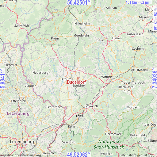
Dudeldorf GPS coordinates[2]
49° 58' 29.784" North, 6° 38' 14.064" East
| Map corner | latitude | longitude |
|---|---|---|
| Upper-left | 50.42501°, | 5.93411° |
| Center: | 49.97494°, | 6.63724° |
| Lower-right: | 49.52062°, | 7.34036° |
| Map W x H: | 100.6×100.6 km | = 62.5×62.5mi |
| max Lat: | 55.01917° ⇑64.4% North |
| Dudeldorf: | 49.97494° |
| min Lat: | ⇓35.6% South 47.40724° |
| min Long | Dudeldorf | max Long |
| 5.92978° | 6.63724° | 14.98853° |
| W 3.2%⇐ | ⇒96.8% E |
Elevation
Elevation of Dudeldorf is 277 m = 909 ft, and this is 27.9 m = 92 ft above average elevation for this country.
| Max E: |
1256 m = 4121 ft | 42.2% |
| Dudeldorf | 277 m 909 ft | |
| Avg. | 249.1 m = 817 ft | |
Min E: |
-5 m = -16 ft | 57.8% |
See also: Germany elevation on elevation.city.
Geographical zone
Dudeldorf is located in North temperate zone (between Tropic of Cancer and the Arctic Circle). Distance of this North polar circle is 1844.5 km =1146.1 mi to North.| Distance of | km | miles | from Dudeldorf |
|---|---|---|---|
| North Pole | 4450.4 | 2765.3 | to North |
| Arctic Circle | 1844.5 | 1146.1 | to North |
| Tropic Cancer | 2950.8 | 1833.5 | to South |
| Equator | 5556.7 | 3452.8 | to South |


Nearby cities:
15 places around Dudeldorf: (largest is in red/bold)
• Badem
3.2 km =2 mi,  332°
332°
• Beilingen
3.5 km =2.2 mi,  142°
142°
• Binsfeld
5.8 km =3.6 mi,  99°
99°
• Dahlem
7 km =4.3 mi,  202°
202°
• Gindorf
4.7 km =2.9 mi,  11°
11°
• Gondorf
1.7 km =1.1 mi,  237°
237°
• Gransdorf
5.7 km =3.5 mi,  35°
35°
• Herforst
5.3 km =3.3 mi,  121°
121°
• Metterich
3.5 km =2.2 mi,  279°
279°
• Orsfeld
6.7 km =4.2 mi,  347°
347°
• Philippsheim
2.8 km =1.7 mi,  185°
185°
• Röhl
6 km =3.7 mi,  219°
219°
• Spangdahlem
3.4 km =2.1 mi,  74°
74°
• Speicher
4.6 km =2.9 mi,  183°
183°
• Wilsecker
6 km =3.7 mi,  320°
320°
Sources, notices
• [Note1] Compared only with cities in Germany existing in our database
• [Src1] Map data: © OpenStreetMap contributors (CC-BY-SA)
• [Src2] Other city data from geonames.org with taken over terms of usage.
• [Src3] Geographical zone / Annual Mean Temperature by Robert A. Rohde @ Wikipedia
