Giersleben geodata
Giersleben (Saxony-Anhalt) is a seat of a fourth-order administrative division; located in Germany in Europe/Berlin (GMT+2) time zone. With population of 1,187 people, there are 6599 cities with bigger population in this country. Compared to other cities in Germany, 69.6% of cities are located further ↓South; 75.3% of cities are located further ←West and 70.9% of cities have higher elevation than Giersleben. Note1


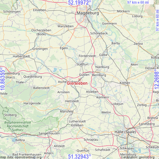
Giersleben GPS coordinates[2]
51° 46' 0.012" North, 11° 34' 0.012" East
| Map corner | latitude | longitude |
|---|---|---|
| Upper-left | 52.19972°, | 10.86355° |
| Center: | 51.76667°, | 11.56667° |
| Lower-right: | 51.32943°, | 12.2698° |
| Map W x H: | 96.8×96.8 km | = 60.1×60.1mi |
| max Lat: | 55.01917° ⇑30.4% North |
| Giersleben: | 51.76667° |
| min Lat: | ⇓69.6% South 47.40724° |
| min Long | Giersleben | max Long |
| 5.92978° | 11.56667° | 14.98853° |
| W 75.3%⇐ | ⇒24.7% E |
Elevation
Elevation of Giersleben is 86 m = 282 ft, and this is 163.1 m = 535 ft below average elevation for this country.
| Max E: |
1256 m = 4121 ft | 70.9% |
| Avg. | 249.1 m = 817 ft | |
| Giersleben | 86 m = 282 ft | |
Min E: |
-5 m = -16 ft | 29.1% |
See also: Germany elevation on elevation.city.
Geographical zone
Giersleben is located in North temperate zone (between Tropic of Cancer and the Arctic Circle). Distance of this North polar circle is 1645.3 km =1022.3 mi to North.| Distance of | km | miles | from Giersleben |
|---|---|---|---|
| North Pole | 4251.1 | 2641.5 | to North |
| Arctic Circle | 1645.3 | 1022.3 | to North |
| Tropic Cancer | 3150 | 1957.3 | to South |
| Equator | 5755.9 | 3576.5 | to South |


Nearby cities:
15 places around Giersleben: (largest is in red/bold)
• Amesdorf
2.7 km =1.7 mi,  58°
58°
• Aschersleben
7.4 km =4.6 mi,  261°
261°
• Drohndorf
6 km =3.7 mi,  203°
203°
• Freckleben
7.3 km =4.5 mi,  190°
190°
• Groß-Schierstedt
3.8 km =2.4 mi,  235°
235°
• Gröna
9 km =5.6 mi,  91°
91°
• Güsten
4.6 km =2.9 mi,  43°
43°
• Hecklingen
9.2 km =5.7 mi,  345°
345°
• Ilberstedt
7.8 km =4.8 mi, 61°
• Mehringen
5.8 km =3.6 mi,  219°
219°
• Neundorf
6 km =3.7 mi,  5°
5°
• Plötzkau
8.2 km =5.1 mi,  102°
102°
• Rathmannsdorf
7.3 km =4.5 mi,  34°
34°
• Staßfurt
9.6 km =6 mi, 7°
• Westdorf
9.7 km =6 mi,  249°
249°
Sources, notices
• [Note1] Compared only with cities in Germany existing in our database
• [Src1] Map data: © OpenStreetMap contributors (CC-BY-SA)
• [Src2] Other city data from geonames.org with taken over terms of usage.
• [Src3] Geographical zone / Annual Mean Temperature by Robert A. Rohde @ Wikipedia
