Rathmannsdorf geodata
Rathmannsdorf (Saxony-Anhalt) is a populated place; located in Germany in Europe/Berlin (GMT+1) time zone. With population of 660 people, there are 8512 cities with bigger population in this country. Compared to other cities in Germany, 70.2% of cities are located further ↓South; 76.1% of cities are located further ←West and 72.8% of cities have higher elevation than Rathmannsdorf. Note1


Rathmannsdorf GPS coordinates[2]
51° 49' 15.204" North, 11° 37' 37.452" East
| Map corner | latitude | longitude |
|---|---|---|
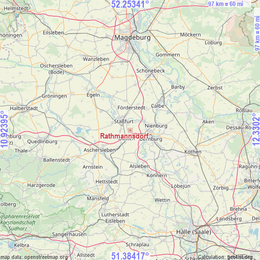
| Upper-left | 52.25341°, | 10.92395° |
| Center: | 51.82089°, | 11.62707° |
| Lower-right: | 51.38417°, | 12.3302° |
| Map W x H: | 96.7×96.6 km | = 60.1×60mi |
| max Lat: | 55.01917° ⇑29.8% North |
| Rathmannsdorf: | 51.82089° |
| min Lat: | ⇓70.2% South 47.40724° |
| min Long | Rathmannsdorf | max Long |
| 5.92978° | 11.62707° | 14.98853° |
| W 76.1%⇐ | ⇒23.9% E |
Elevation
Elevation of Rathmannsdorf is 73 m = 240 ft, and this is 176.1 m = 578 ft below average elevation for this country.
| Max E: |
1256 m = 4121 ft | 72.8% |
| Avg. | 249.1 m = 817 ft | |
| Rathmannsdorf | 73 m = 240 ft | |
Min E: |
-5 m = -16 ft | 27.2% |
See also: Germany elevation on elevation.city.
Geographical zone
Rathmannsdorf is located in North temperate zone (between Tropic of Cancer and the Arctic Circle). Distance of this North polar circle is 1639.2 km =1018.6 mi to North.| Distance of | km | miles | from Rathmannsdorf |
|---|---|---|---|
| North Pole | 4245.1 | 2637.8 | to North |
| Arctic Circle | 1639.2 | 1018.6 | to North |
| Tropic Cancer | 3156 | 1961 | to South |
| Equator | 5761.9 | 3580.3 | to South |


Nearby cities:
15 places around Rathmannsdorf: (largest is in red/bold)
• Amesdorf
4.9 km =3 mi,  201°
201°
• Bernburg
8.3 km =5.2 mi,  110°
110°
• Brumby
10.4 km =6.5 mi,  36°
36°
• Förderstedt
8.5 km =5.3 mi,  2°
2°
• Giersleben
7.3 km =4.5 mi,  214°
214°
• Glöthe
10.4 km =6.5 mi,  18°
18°
• Gröna
7.9 km =4.9 mi,  142°
142°
• Güsten
2.9 km =1.8 mi, 200°
• Hecklingen
7 km =4.3 mi,  294°
294°
• Ilberstedt
3.6 km =2.2 mi,  130°
130°
• Neugattersleben
6.5 km =4 mi,  58°
58°
• Neundorf
3.6 km =2.2 mi,  269°
269°
• Nienburg/Saale
10 km =6.2 mi,  79°
79°
• Plötzkau
8.8 km =5.5 mi,  153°
153°
• Staßfurt
4.5 km =2.8 mi,  320°
320°
Sources, notices
• [Note1] Compared only with cities in Germany existing in our database
• [Src1] Map data: © OpenStreetMap contributors (CC-BY-SA)
• [Src2] Other city data from geonames.org with taken over terms of usage.
• [Src3] Geographical zone / Annual Mean Temperature by Robert A. Rohde @ Wikipedia
