Amesdorf geodata
Amesdorf (Saxony-Anhalt) is a populated place; located in Germany in Europe/Berlin (GMT+2) time zone. With population of 814 people, there are 7845 cities with bigger population in this country. Compared to other cities in Germany, 69.7% of cities are located further ↓South; 75.8% of cities are located further ←West and 71% of cities have higher elevation than Amesdorf. Note1


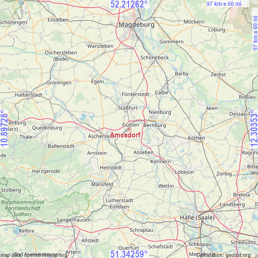
Amesdorf GPS coordinates[2]
51° 46' 46.92" North, 11° 36' 1.44" East
| Map corner | latitude | longitude |
|---|---|---|
| Upper-left | 52.21262°, | 10.89728° |
| Center: | 51.7797°, | 11.6004° |
| Lower-right: | 51.34259°, | 12.30353° |
| Map W x H: | 96.7×96.7 km | = 60.1×60.1mi |
| max Lat: | 55.01917° ⇑30.3% North |
| Amesdorf: | 51.7797° |
| min Lat: | ⇓69.7% South 47.40724° |
| min Long | Amesdorf | max Long |
| 5.92978° | 11.6004° | 14.98853° |
| W 75.8%⇐ | ⇒24.2% E |
Elevation
Elevation of Amesdorf is 85 m = 279 ft, and this is 164.1 m = 538 ft below average elevation for this country.
| Max E: |
1256 m = 4121 ft | 71% |
| Avg. | 249.1 m = 817 ft | |
| Amesdorf | 85 m = 279 ft | |
Min E: |
-5 m = -16 ft | 29% |
See also: Germany elevation on elevation.city.
Geographical zone
Amesdorf is located in North temperate zone (between Tropic of Cancer and the Arctic Circle). Distance of this North polar circle is 1643.8 km =1021.4 mi to North.| Distance of | km | miles | from Amesdorf |
|---|---|---|---|
| North Pole | 4249.7 | 2640.6 | to North |
| Arctic Circle | 1643.8 | 1021.4 | to North |
| Tropic Cancer | 3151.4 | 1958.2 | to South |
| Equator | 5757.4 | 3577.5 | to South |


Nearby cities:
15 places around Amesdorf: (largest is in red/bold)
• Aschersleben
9.9 km =6.2 mi,  255°
255°
• Bernburg
9.8 km =6.1 mi,  80°
80°
• Drohndorf
8.4 km =5.2 mi,  214°
214°
• Freckleben
9.4 km =5.8 mi,  203°
203°
• Giersleben
2.7 km =1.7 mi,  238°
238°
• Groß-Schierstedt
6.5 km =4 mi, 236°
• Gröna
6.9 km =4.3 mi,  104°
104°
• Güsten
2 km =1.2 mi,  24°
24°
• Hecklingen
8.8 km =5.5 mi,  328°
328°
• Ilberstedt
5.1 km =3.2 mi,  63°
63°
• Mehringen
8.4 km =5.2 mi,  225°
225°
• Neundorf
4.9 km =3 mi,  338°
338°
• Plötzkau
6.6 km =4.1 mi,  120°
120°
• Rathmannsdorf
4.9 km =3 mi, 21°
• Staßfurt
8.1 km =5 mi,  352°
352°
Sources, notices
• [Note1] Compared only with cities in Germany existing in our database
• [Src1] Map data: © OpenStreetMap contributors (CC-BY-SA)
• [Src2] Other city data from geonames.org with taken over terms of usage.
• [Src3] Geographical zone / Annual Mean Temperature by Robert A. Rohde @ Wikipedia
