Gangelt geodata
Gangelt (North Rhine-Westphalia) is a seat of a fourth-order administrative division; located in Germany in Europe/Berlin (GMT+2) time zone. With population of 11,484 people, there are 1434 cities with bigger population in this country. Compared to other cities in Germany, 58% of cities are located further ↓South; 100% of cities are located further →East and 72.1% of cities have higher elevation than Gangelt. Note1
Administrative division(s):
- Level 1: North Rhine-Westphalia
- Level 2: Regierungsbezirk Köln
- Level 3: Kreis Heinsberg
- Level 4: Gangelt


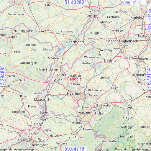
Gangelt GPS coordinates[2]
50° 59' 32.892" North, 5° 59' 52.872" East
| Map corner | latitude | longitude |
|---|---|---|
| Upper-left | 51.43292°, | 5.29489° |
| Center: | 50.99247°, | 5.99802° |
| Lower-right: | 50.54779°, | 6.70114° |
| Map W x H: | 98.4×98.4 km | = 61.1×61.1mi |
| max Lat: | 55.01917° ⇑42% North |
| Gangelt: | 50.99247° |
| min Lat: | ⇓58% South 47.40724° |
| min Long | Gangelt | max Long |
| 5.92978° | 5.99802° | 14.98853° |
| W 0%⇐ | ⇒100% E |
Elevation
Elevation of Gangelt is 77 m = 253 ft, and this is 172.1 m = 565 ft below average elevation for this country.
| Max E: |
1256 m = 4121 ft | 72.1% |
| Avg. | 249.1 m = 817 ft | |
| Gangelt | 77 m = 253 ft | |
Min E: |
-5 m = -16 ft | 27.9% |
See also: Germany elevation on elevation.city.
Geographical zone
Gangelt is located in North temperate zone (between Tropic of Cancer and the Arctic Circle). Distance of this North polar circle is 1731.3 km =1075.8 mi to North.| Distance of | km | miles | from Gangelt |
|---|---|---|---|
| North Pole | 4337.2 | 2695 | to North |
| Arctic Circle | 1731.3 | 1075.8 | to North |
| Tropic Cancer | 3063.9 | 1903.8 | to South |
| Equator | 5669.8 | 3523 | to South |


Nearby cities:
15 places around Gangelt: (largest is in red/bold)
• Alsdorf
17.3 km =10.7 mi,  137°
137°
• Baesweiler
16.2 km =10.1 mi,  124°
124°
• Dürboslar
20.5 km =12.7 mi, 118°
• Freialdenhoven
19 km =11.8 mi,  112°
112°
• Geilenkirchen
8.8 km =5.5 mi, 108°
• Heinsberg
10.6 km =6.6 mi,  41°
41°
• Herzogenrath
15.3 km =9.5 mi,  154°
154°
• Hückelhoven
17.5 km =10.9 mi,  66°
66°
• Linnich
19.1 km =11.9 mi,  94°
94°
• Schleiden
21 km =13 mi,  125°
125°
• Selfkant
5.8 km =3.6 mi,  304°
304°
• Siersdorf
19.1 km =11.9 mi, 123°
• Waldfeucht
8.2 km =5.1 mi,  355°
355°
• Wassenberg
16.2 km =10.1 mi, 42°
• Übach-Palenberg
12.1 km =7.5 mi, 133°
Sources, notices
• [Note1] Compared only with cities in Germany existing in our database
• [Src1] Map data: © OpenStreetMap contributors (CC-BY-SA)
• [Src2] Other city data from geonames.org with taken over terms of usage.
• [Src3] Geographical zone / Annual Mean Temperature by Robert A. Rohde @ Wikipedia
