Wassenberg geodata
Wassenberg (North Rhine-Westphalia) is a populated place; located in Germany in Europe/Berlin (GMT+2) time zone. With population of 16,641 people, there are 949 cities with bigger population in this country. Compared to other cities in Germany, 59.9% of cities are located further ↓South; 99.9% of cities are located further →East and 79.4% of cities have higher elevation than Wassenberg. Note1
Administrative division(s):
- Level 1: North Rhine-Westphalia
- Level 2: Regierungsbezirk Köln
- Level 3: Kreis Heinsberg
- Level 4: Wassenberg


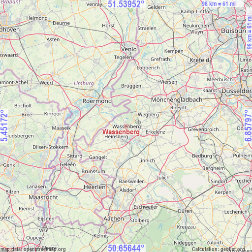
Wassenberg GPS coordinates[2]
51° 6' 0.324" North, 6° 9' 17.424" East
| Map corner | latitude | longitude |
|---|---|---|
| Upper-left | 51.53952°, | 5.45172° |
| Center: | 51.10009°, | 6.15484° |
| Lower-right: | 50.65644°, | 6.85797° |
| Map W x H: | 98.2×98.2 km | = 61×61mi |
| max Lat: | 55.01917° ⇑40.1% North |
| Wassenberg: | 51.10009° |
| min Lat: | ⇓59.9% South 47.40724° |
| min Long | Wassenberg | max Long |
| 5.92978° | 6.15484° | 14.98853° |
| W 0.1%⇐ | ⇒99.9% E |
Elevation
Elevation of Wassenberg is 48 m = 157 ft, and this is 201.1 m = 660 ft below average elevation for this country.
| Max E: |
1256 m = 4121 ft | 79.4% |
| Avg. | 249.1 m = 817 ft | |
| Wassenberg | 48 m = 157 ft | |
Min E: |
-5 m = -16 ft | 20.6% |
See also: Germany elevation on elevation.city.
Geographical zone
Wassenberg is located in North temperate zone (between Tropic of Cancer and the Arctic Circle). Distance of this North polar circle is 1719.4 km =1068.4 mi to North.| Distance of | km | miles | from Wassenberg |
|---|---|---|---|
| North Pole | 4325.3 | 2687.6 | to North |
| Arctic Circle | 1719.4 | 1068.4 | to North |
| Tropic Cancer | 3075.9 | 1911.3 | to South |
| Equator | 5681.8 | 3530.5 | to South |


Nearby cities:
15 places around Wassenberg: (largest is in red/bold)
• Baesweiler
21.3 km =13.2 mi,  173°
173°
• Brüggen
15.7 km =9.8 mi,  7°
7°
• Erkelenz
11.4 km =7.1 mi,  101°
101°
• Freialdenhoven
20.2 km =12.6 mi,  161°
161°
• Gangelt
16.2 km =10.1 mi,  222°
222°
• Geilenkirchen
15 km =9.3 mi,  190°
190°
• Heinsberg
5.6 km =3.5 mi, 223°
• Hückelhoven
7 km =4.3 mi,  134°
134°
• Linnich
15.6 km =9.7 mi,  148°
148°
• Niederkrüchten
11.9 km =7.4 mi,  21°
21°
• Schwalmtal
15.1 km =9.4 mi,  31°
31°
• Selfkant
18 km =11.2 mi,  241°
241°
• Waldfeucht
12.2 km =7.6 mi,  252°
252°
• Wegberg
10.2 km =6.3 mi,  62°
62°
• Übach-Palenberg
20.4 km =12.7 mi, 186°
Sources, notices
• [Note1] Compared only with cities in Germany existing in our database
• [Src1] Map data: © OpenStreetMap contributors (CC-BY-SA)
• [Src2] Other city data from geonames.org with taken over terms of usage.
• [Src3] Geographical zone / Annual Mean Temperature by Robert A. Rohde @ Wikipedia
