Friedland geodata
Friedland (Brandenburg) is a populated place; located in Germany in Europe/Berlin (GMT+2) time zone. With population of 3,597 people, there are 3544 cities with bigger population in this country. Compared to other cities in Germany, 73.1% of cities are located further ↓South; 98.8% of cities are located further ←West and 77.9% of cities have higher elevation than Friedland. Note1


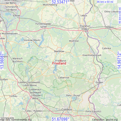
Friedland GPS coordinates[2]
52° 6' 17.748" North, 14° 15' 50.364" East
| Map corner | latitude | longitude |
|---|---|---|
| Upper-left | 52.53471°, | 13.56087° |
| Center: | 52.10493°, | 14.26399° |
| Lower-right: | 51.67096°, | 14.96712° |
| Map W x H: | 96×96 km | = 59.7×59.7mi |
| max Lat: | 55.01917° ⇑26.9% North |
| Friedland: | 52.10493° |
| min Lat: | ⇓73.1% South 47.40724° |
| min Long | Friedland | max Long |
| 5.92978° | 14.26399° | 14.98853° |
| W 98.8%⇐ | ⇒1.2% E |
Elevation
Elevation of Friedland is 53 m = 174 ft, and this is 196.1 m = 643 ft below average elevation for this country.
| Max E: |
1256 m = 4121 ft | 77.9% |
| Avg. | 249.1 m = 817 ft | |
| Friedland | 53 m = 174 ft | |
Min E: |
-5 m = -16 ft | 22.1% |
See also: Germany elevation on elevation.city.
Geographical zone
Friedland is located in North temperate zone (between Tropic of Cancer and the Arctic Circle). Distance of this North polar circle is 1607.6 km =998.9 mi to North.| Distance of | km | miles | from Friedland |
|---|---|---|---|
| North Pole | 4213.5 | 2618.1 | to North |
| Arctic Circle | 1607.6 | 998.9 | to North |
| Tropic Cancer | 3187.6 | 1980.7 | to South |
| Equator | 5793.5 | 3599.9 | to South |


Nearby cities:
15 places around Friedland: (largest is in red/bold)
• Bad Saarow
24 km =14.9 mi,  325°
325°
• Beeskow
7.7 km =4.8 mi,  350°
350°
• Diensdorf-Radlow
21.8 km =13.5 mi,  317°
317°
• Drachhausen
24.1 km =15 mi,  171°
171°
• Groß Lindow
23.3 km =14.5 mi,  52°
52°
• Jamlitz
14.3 km =8.9 mi,  152°
152°
• Lieberose
13.6 km =8.5 mi, 169°
• Mixdorf
14.1 km =8.8 mi,  41°
41°
• Müllrose
19 km =11.8 mi,  33°
33°
• Neu Zauche
23.1 km =14.4 mi,  211°
211°
• Reichenwalde
25.4 km =15.8 mi,  314°
314°
• Rietz Neuendorf
14.9 km =9.3 mi,  335°
335°
• Straupitz
23.4 km =14.5 mi,  204°
204°
• Tauche
8.3 km =5.2 mi, 307°
• Wendisch Rietz
21.4 km =13.3 mi, 305°
Sources, notices
• [Note1] Compared only with cities in Germany existing in our database
• [Src1] Map data: © OpenStreetMap contributors (CC-BY-SA)
• [Src2] Other city data from geonames.org with taken over terms of usage.
• [Src3] Geographical zone / Annual Mean Temperature by Robert A. Rohde @ Wikipedia
