Müllrose geodata
Müllrose (Brandenburg) is a populated place; located in Germany in Europe/Berlin (GMT+2) time zone. With population of 4,461 people, there are 3054 cities with bigger population in this country. Compared to other cities in Germany, 74.6% of cities are located further ↓South; 99.2% of cities are located further ←West and 81.4% of cities have higher elevation than Müllrose. Note1


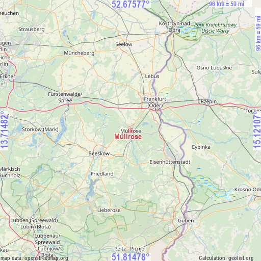
Müllrose GPS coordinates[2]
52° 14' 50.496" North, 14° 25' 4.584" East
| Map corner | latitude | longitude |
|---|---|---|
| Upper-left | 52.67577°, | 13.71482° |
| Center: | 52.24736°, | 14.41794° |
| Lower-right: | 51.81478°, | 15.12107° |
| Map W x H: | 95.7×95.7 km | = 59.5×59.5mi |
| max Lat: | 55.01917° ⇑25.4% North |
| Müllrose: | 52.24736° |
| min Lat: | ⇓74.6% South 47.40724° |
| min Long | Müllrose | max Long |
| 5.92978° | 14.41794° | 14.98853° |
| W 99.2%⇐ | ⇒0.8% E |
Elevation
Elevation of Müllrose is 43 m = 141 ft, and this is 206.1 m = 676 ft below average elevation for this country.
| Max E: |
1256 m = 4121 ft | 81.4% |
| Avg. | 249.1 m = 817 ft | |
| Müllrose | 43 m = 141 ft | |
Min E: |
-5 m = -16 ft | 18.6% |
See also: Germany elevation on elevation.city.
Geographical zone
Müllrose is located in North temperate zone (between Tropic of Cancer and the Arctic Circle). Distance of this North polar circle is 1591.8 km =989.1 mi to North.| Distance of | km | miles | from Müllrose |
|---|---|---|---|
| North Pole | 4197.7 | 2608.3 | to North |
| Arctic Circle | 1591.8 | 989.1 | to North |
| Tropic Cancer | 3203.4 | 1990.5 | to South |
| Equator | 5809.4 | 3609.8 | to South |


Nearby cities:
15 places around Müllrose: (largest is in red/bold)
• Beeskow
14.3 km =8.9 mi,  234°
234°
• Briesen
14.3 km =8.9 mi,  318°
318°
• Brieskow-Finkenheerd
10.6 km =6.6 mi,  86°
86°
• Eisenhüttenstadt
19.2 km =11.9 mi,  124°
124°
• Frankfurt (Oder)
14.3 km =8.9 mi,  39°
39°
• Friedland
19 km =11.8 mi,  213°
213°
• Groß Lindow
8 km =5 mi,  101°
101°
• Jacobsdorf
10.6 km =6.6 mi,  334°
334°
• Mixdorf
5.4 km =3.4 mi,  193°
193°
• Rietz Neuendorf
16.7 km =10.4 mi,  262°
262°
• Tauche
20.3 km =12.6 mi,  237°
237°
• Treplin
17 km =10.6 mi,  355°
355°
• Vogelsang
18.2 km =11.3 mi,  113°
113°
• Wiesenau
11.9 km =7.4 mi, 98°
• Ziltendorf
14.8 km =9.2 mi, 108°
Sources, notices
• [Note1] Compared only with cities in Germany existing in our database
• [Src1] Map data: © OpenStreetMap contributors (CC-BY-SA)
• [Src2] Other city data from geonames.org with taken over terms of usage.
• [Src3] Geographical zone / Annual Mean Temperature by Robert A. Rohde @ Wikipedia
