Frettenheim geodata
Frettenheim (Rheinland-Pfalz) is a seat of a fourth-order administrative division; located in Germany in Europe/Berlin (GMT+2) time zone. With population of 334 people, there are 9927 cities with bigger population in this country. Compared to other cities in Germany, 69.9% of cities are located further ↑North; 73.6% of cities are located further →East and 58% of cities have higher elevation than Frettenheim. Note1
Administrative division(s):
- Level 1: Rheinland-Pfalz
- Level 3: Landkreis Alzey-Worms
- Level 4: Frettenheim


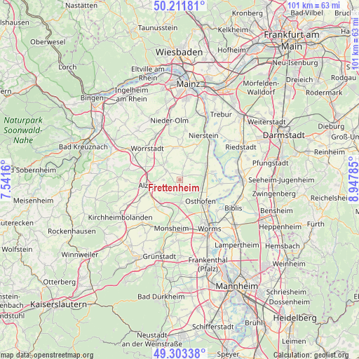
Frettenheim GPS coordinates[2]
49° 45' 34.992" North, 8° 14' 40.992" East
| Map corner | latitude | longitude |
|---|---|---|
| Upper-left | 50.21181°, | 7.5416° |
| Center: | 49.75972°, | 8.24472° |
| Lower-right: | 49.30338°, | 8.94785° |
| Map W x H: | 101×101 km | = 62.8×62.8mi |
| max Lat: | 55.01917° ⇑69.9% North |
| Frettenheim: | 49.75972° |
| min Lat: | ⇓30.1% South 47.40724° |
| min Long | Frettenheim | max Long |
| 5.92978° | 8.24472° | 14.98853° |
| W 26.4%⇐ | ⇒73.6% E |
Elevation
Elevation of Frettenheim is 168 m = 551 ft, and this is 81.1 m = 266 ft below average elevation for this country.
| Max E: |
1256 m = 4121 ft | 58% |
| Avg. | 249.1 m = 817 ft | |
| Frettenheim | 168 m = 551 ft | |
Min E: |
-5 m = -16 ft | 42% |
See also: Germany elevation on elevation.city.
Geographical zone
Frettenheim is located in North temperate zone (between Tropic of Cancer and the Arctic Circle). Distance of this North polar circle is 1868.4 km =1161 mi to North.| Distance of | km | miles | from Frettenheim |
|---|---|---|---|
| North Pole | 4474.3 | 2780.2 | to North |
| Arctic Circle | 1868.4 | 1161 | to North |
| Tropic Cancer | 2926.8 | 1818.6 | to South |
| Equator | 5532.8 | 3437.9 | to South |


Nearby cities:
15 places around Frettenheim: (largest is in red/bold)
• Bechtheim
4.9 km =3 mi,  136°
136°
• Bechtolsheim
6.1 km =3.8 mi,  323°
323°
• Dittelsheim-Heßloch
1.8 km =1.1 mi,  197°
197°
• Dolgesheim
4 km =2.5 mi,  12°
12°
• Dorn-Dürkheim
2 km =1.2 mi,  61°
61°
• Eimsheim
5.1 km =3.2 mi,  38°
38°
• Framersheim
5.1 km =3.2 mi,  267°
267°
• Gau-Heppenheim
5.5 km =3.4 mi,  249°
249°
• Gau-Odernheim
4.6 km =2.9 mi,  307°
307°
• Hillesheim
2 km =1.2 mi,  23°
23°
• Hochborn
5.1 km =3.2 mi,  218°
218°
• Mettenheim
6.2 km =3.9 mi,  110°
110°
• Monzernheim
4.4 km =2.7 mi, 195°
• Westhofen
6.2 km =3.9 mi,  177°
177°
• Wintersheim
3.3 km =2.1 mi,  50°
50°
Sources, notices
• [Note1] Compared only with cities in Germany existing in our database
• [Src1] Map data: © OpenStreetMap contributors (CC-BY-SA)
• [Src2] Other city data from geonames.org with taken over terms of usage.
• [Src3] Geographical zone / Annual Mean Temperature by Robert A. Rohde @ Wikipedia
