Bechtolsheim geodata
Bechtolsheim (Rheinland-Pfalz) is a seat of a fourth-order administrative division; located in Germany in Europe/Berlin (GMT+2) time zone. With population of 1,489 people, there are 5904 cities with bigger population in this country. Compared to other cities in Germany, 68.8% of cities are located further ↑North; 74.2% of cities are located further →East and 61.3% of cities have higher elevation than Bechtolsheim. Note1
Administrative division(s):
- Level 1: Rheinland-Pfalz
- Level 3: Landkreis Alzey-Worms
- Level 4: Bechtolsheim


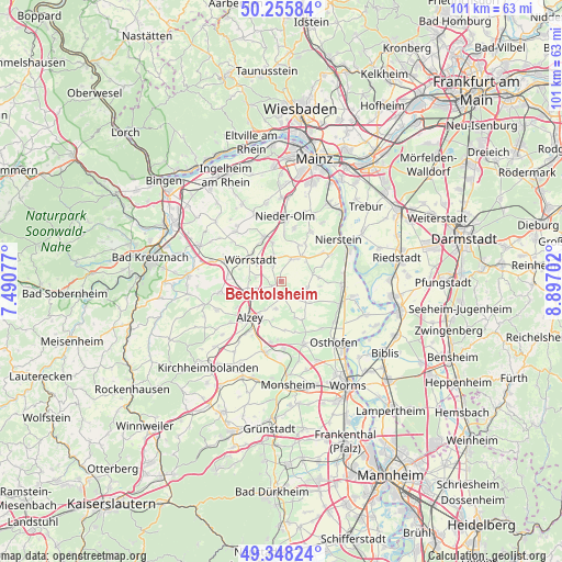
Bechtolsheim GPS coordinates[2]
49° 48' 15.012" North, 8° 11' 38.004" East
| Map corner | latitude | longitude |
|---|---|---|
| Upper-left | 50.25584°, | 7.49077° |
| Center: | 49.80417°, | 8.19389° |
| Lower-right: | 49.34824°, | 8.89702° |
| Map W x H: | 100.9×100.9 km | = 62.7×62.7mi |
| max Lat: | 55.01917° ⇑68.8% North |
| Bechtolsheim: | 49.80417° |
| min Lat: | ⇓31.2% South 47.40724° |
| min Long | Bechtolsheim | max Long |
| 5.92978° | 8.19389° | 14.98853° |
| W 25.8%⇐ | ⇒74.2% E |
Elevation
Elevation of Bechtolsheim is 144 m = 472 ft, and this is 105.1 m = 345 ft below average elevation for this country.
| Max E: |
1256 m = 4121 ft | 61.3% |
| Avg. | 249.1 m = 817 ft | |
| Bechtolsheim | 144 m = 472 ft | |
Min E: |
-5 m = -16 ft | 38.7% |
See also: Germany elevation on elevation.city.
Geographical zone
Bechtolsheim is located in North temperate zone (between Tropic of Cancer and the Arctic Circle). Distance of this North polar circle is 1863.5 km =1157.9 mi to North.| Distance of | km | miles | from Bechtolsheim |
|---|---|---|---|
| North Pole | 4469.4 | 2777.2 | to North |
| Arctic Circle | 1863.5 | 1157.9 | to North |
| Tropic Cancer | 2931.8 | 1821.7 | to South |
| Equator | 5537.7 | 3441 | to South |


Nearby cities:
15 places around Bechtolsheim: (largest is in red/bold)
• Albig
6.2 km =3.9 mi,  236°
236°
• Biebelnheim
1.9 km =1.2 mi, 243°
• Dolgesheim
4.7 km =2.9 mi,  103°
103°
• Ensheim
5.6 km =3.5 mi,  272°
272°
• Framersheim
5.3 km =3.3 mi,  195°
195°
• Frettenheim
6.1 km =3.8 mi,  143°
143°
• Friesenheim
5.8 km =3.6 mi,  51°
51°
• Gabsheim
2.9 km =1.8 mi,  334°
334°
• Gau-Odernheim
2.2 km =1.4 mi,  179°
179°
• Hillesheim
5.4 km =3.4 mi,  124°
124°
• Köngernheim
6 km =3.7 mi,  39°
39°
• Schornsheim
4.8 km =3 mi,  343°
343°
• Spiesheim
4.8 km =3 mi,  278°
278°
• Undenheim
4.2 km =2.6 mi,  25°
25°
• Weinolsheim
5.8 km =3.6 mi,  77°
77°
Sources, notices
• [Note1] Compared only with cities in Germany existing in our database
• [Src1] Map data: © OpenStreetMap contributors (CC-BY-SA)
• [Src2] Other city data from geonames.org with taken over terms of usage.
• [Src3] Geographical zone / Annual Mean Temperature by Robert A. Rohde @ Wikipedia
