Eisenberg geodata
Eisenberg (Bavaria) is a seat of a fourth-order administrative division; located in Germany in Europe/Berlin (GMT+2) time zone. In our database, there are 11009 cities with bigger population. Compared to other cities in Germany, 99.6% of cities are located further ↑North; 60.9% of cities are located further ←West and 99.4% of cities have lower elevation than Eisenberg. Note1
Administrative division(s):
- Level 1: Bavaria
- Level 2: Swabia
- Level 3: Landkreis Ostallgäu
- Level 4: Eisenberg (Allgäu)


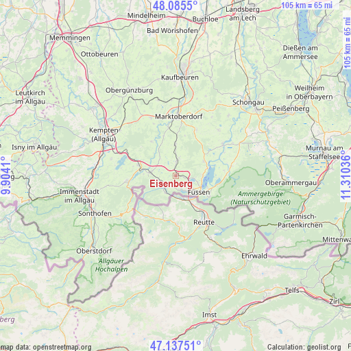
Eisenberg GPS coordinates[2]
47° 36' 49.14" North, 10° 36' 26.028" East
| Map corner | latitude | longitude |
|---|---|---|
| Upper-left | 48.0855°, | 9.9041° |
| Center: | 47.61365°, | 10.60723° |
| Lower-right: | 47.13751°, | 11.31036° |
| Map W x H: | 105.4×105.4 km | = 65.5×65.5mi |
| max Lat: | 55.01917° ⇑99.6% North |
| Eisenberg: | 47.61365° |
| min Lat: | ⇓0.4% South 47.40724° |
| min Long | Eisenberg | max Long |
| 5.92978° | 10.60723° | 14.98853° |
| W 60.9%⇐ | ⇒39.1% E |
Elevation
Elevation of Eisenberg is 832 m = 2730 ft, and this is 582.9 m = 1912 ft above average elevation for this country.
| Max E: |
1256 m = 4121 ft | 0.59999999999999% |
| Eisenberg | 832 m 2730 ft | |
| Avg. | 249.1 m = 817 ft | |
Min E: |
-5 m = -16 ft | 99.4% |
See also: Germany elevation on elevation.city.
Geographical zone
Eisenberg is located in North temperate zone (between Tropic of Cancer and the Arctic Circle). Distance of this North polar circle is 2107 km =1309.2 mi to North.| Distance of | km | miles | from Eisenberg |
|---|---|---|---|
| North Pole | 4712.9 | 2928.5 | to North |
| Arctic Circle | 2107 | 1309.2 | to North |
| Tropic Cancer | 2688.2 | 1670.4 | to South |
| Equator | 5294.1 | 3289.6 | to South |


Nearby cities:
15 places around Eisenberg: (largest is in red/bold)
• Füssen
8.5 km =5.3 mi,  123°
123°
• Görisried
12.6 km =7.8 mi,  324°
324°
• Hohenschwangau
11.9 km =7.4 mi, 122°
• Hopferau
2 km =1.2 mi,  80°
80°
• Lengenwang
9.6 km =6 mi,  356°
356°
• Nesselwang
7.9 km =4.9 mi,  277°
277°
• Oy-Mittelberg
13.2 km =8.2 mi, 279°
• Pfronten
5.6 km =3.5 mi,  231°
231°
• Roßhaupten
9.1 km =5.7 mi,  63°
63°
• Rückholz
7.3 km =4.5 mi, 323°
• Schwangau
10.3 km =6.4 mi,  113°
113°
• Seeg
4.1 km =2.5 mi,  352°
352°
• Stötten am Auerberg
15.2 km =9.4 mi,  23°
23°
• Wald
12.7 km =7.9 mi,  343°
343°
• Wertach
14.9 km =9.3 mi,  265°
265°
Sources, notices
• [Note1] Compared only with cities in Germany existing in our database
• [Src1] Map data: © OpenStreetMap contributors (CC-BY-SA)
• [Src2] Other city data from geonames.org with taken over terms of usage.
• [Src3] Geographical zone / Annual Mean Temperature by Robert A. Rohde @ Wikipedia
