Wertach geodata
Wertach (Bavaria) is a populated place; located in Germany in Europe/Berlin (GMT+2) time zone. With population of 2,423 people, there are 4532 cities with bigger population in this country. Compared to other cities in Germany, 99.6% of cities are located further ↑North; 57.2% of cities are located further ←West and 99.8% of cities have lower elevation than Wertach. Note1
Administrative division(s):
- Level 1: Bavaria
- Level 2: Swabia
- Level 3: Landkreis Oberallgäu
- Level 4: Wertach, Markt


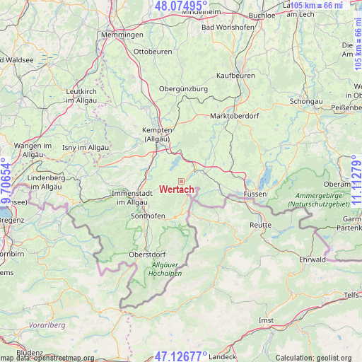
Wertach GPS coordinates[2]
47° 36' 10.836" North, 10° 24' 34.776" East
| Map corner | latitude | longitude |
|---|---|---|
| Upper-left | 48.07495°, | 9.70654° |
| Center: | 47.60301°, | 10.40966° |
| Lower-right: | 47.12677°, | 11.11279° |
| Map W x H: | 105.4×105.4 km | = 65.5×65.5mi |
| max Lat: | 55.01917° ⇑99.6% North |
| Wertach: | 47.60301° |
| min Lat: | ⇓0.4% South 47.40724° |
| min Long | Wertach | max Long |
| 5.92978° | 10.40966° | 14.98853° |
| W 57.2%⇐ | ⇒42.8% E |
Elevation
Elevation of Wertach is 905 m = 2969 ft, and this is 655.9 m = 2152 ft above average elevation for this country.
| Max E: |
1256 m = 4121 ft | 0.2% |
| Wertach | 905 m 2969 ft | |
| Avg. | 249.1 m = 817 ft | |
Min E: |
-5 m = -16 ft | 99.8% |
See also: Germany elevation on elevation.city.
Geographical zone
Wertach is located in North temperate zone (between Tropic of Cancer and the Arctic Circle). Distance of this North polar circle is 2108.2 km =1310 mi to North.| Distance of | km | miles | from Wertach |
|---|---|---|---|
| North Pole | 4714.1 | 2929.2 | to North |
| Arctic Circle | 2108.2 | 1310 | to North |
| Tropic Cancer | 2687 | 1669.6 | to South |
| Equator | 5293 | 3288.9 | to South |


Nearby cities:
15 places around Wertach: (largest is in red/bold)
• Betzigau
14.6 km =9.1 mi,  352°
352°
• Blaichach
13.2 km =8.2 mi,  239°
239°
• Burgberg
11.7 km =7.3 mi,  230°
230°
• Durach
11.3 km =7 mi,  334°
334°
• Eisenberg
14.9 km =9.3 mi,  85°
85°
• Görisried
13.8 km =8.6 mi,  33°
33°
• Nesselwang
7.3 km =4.5 mi,  71°
71°
• Oy-Mittelberg
3.8 km =2.4 mi, 27°
• Pfronten
10.7 km =6.6 mi,  102°
102°
• Rettenberg
9.4 km =5.8 mi,  250°
250°
• Rückholz
12.7 km =7.9 mi,  56°
56°
• Seeg
15.2 km =9.4 mi, 69°
• Sonthofen
13.4 km =8.3 mi, 225°
• Sulzberg
7.8 km =4.8 mi,  324°
324°
• Waltenhofen
11 km =6.8 mi, 315°
Sources, notices
• [Note1] Compared only with cities in Germany existing in our database
• [Src1] Map data: © OpenStreetMap contributors (CC-BY-SA)
• [Src2] Other city data from geonames.org with taken over terms of usage.
• [Src3] Geographical zone / Annual Mean Temperature by Robert A. Rohde @ Wikipedia
