Egenhausen geodata
Egenhausen (Baden-Württemberg) is a seat of a fourth-order administrative division; located in Germany in Europe/Berlin (GMT+2) time zone. With population of 2,025 people, there are 5033 cities with bigger population in this country. Compared to other cities in Germany, 88.3% of cities are located further ↑North; 70% of cities are located further →East and 92.4% of cities have lower elevation than Egenhausen. Note1
Administrative division(s):
- Level 1: Baden-Württemberg
- Level 2: Karlsruhe Region
- Level 3: Landkreis Calw
- Level 4: Egenhausen


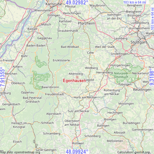
Egenhausen GPS coordinates[2]
48° 34' 0.012" North, 8° 37' 0.012" East
| Map corner | latitude | longitude |
|---|---|---|
| Upper-left | 49.02982°, | 7.91355° |
| Center: | 48.56667°, | 8.61667° |
| Lower-right: | 48.09924°, | 9.3198° |
| Map W x H: | 103.5×103.5 km | = 64.3×64.3mi |
| max Lat: | 55.01917° ⇑88.3% North |
| Egenhausen: | 48.56667° |
| min Lat: | ⇓11.7% South 47.40724° |
| min Long | Egenhausen | max Long |
| 5.92978° | 8.61667° | 14.98853° |
| W 30%⇐ | ⇒70% E |
Elevation
Elevation of Egenhausen is 549 m = 1801 ft, and this is 299.9 m = 984 ft above average elevation for this country.
| Max E: |
1256 m = 4121 ft | 7.6% |
| Egenhausen | 549 m 1801 ft | |
| Avg. | 249.1 m = 817 ft | |
Min E: |
-5 m = -16 ft | 92.4% |
See also: Germany elevation on elevation.city.
Geographical zone
Egenhausen is located in North temperate zone (between Tropic of Cancer and the Arctic Circle). Distance of this North polar circle is 2001.1 km =1243.4 mi to North.| Distance of | km | miles | from Egenhausen |
|---|---|---|---|
| North Pole | 4607 | 2862.7 | to North |
| Arctic Circle | 2001.1 | 1243.4 | to North |
| Tropic Cancer | 2794.2 | 1736.2 | to South |
| Equator | 5400.1 | 3355.5 | to South |


Nearby cities:
15 places around Egenhausen: (largest is in red/bold)
• Altensteig
2.4 km =1.5 mi,  336°
336°
• Ebhausen
5.2 km =3.2 mi,  69°
69°
• Grömbach
5.3 km =3.3 mi,  277°
277°
• Haiterbach
5.5 km =3.4 mi,  158°
158°
• Mötzingen
12.2 km =7.6 mi,  107°
107°
• Nagold
8.1 km =5 mi,  103°
103°
• Neubulach
12 km =7.5 mi,  29°
29°
• Neuweiler
11.2 km =7 mi,  353°
353°
• Oberjettingen
11.8 km =7.3 mi,  85°
85°
• Pfalzgrafenweiler
5.8 km =3.6 mi,  219°
219°
• Rohrdorf
6.1 km =3.8 mi, 90°
• Simmersfeld
9.2 km =5.7 mi,  307°
307°
• Unterjettingen
12.4 km =7.7 mi, 92°
• Wildberg
11.4 km =7.1 mi,  56°
56°
• Wörnersberg
3.7 km =2.3 mi,  270°
270°
Sources, notices
• [Note1] Compared only with cities in Germany existing in our database
• [Src1] Map data: © OpenStreetMap contributors (CC-BY-SA)
• [Src2] Other city data from geonames.org with taken over terms of usage.
• [Src3] Geographical zone / Annual Mean Temperature by Robert A. Rohde @ Wikipedia
