Dorsel geodata
Dorsel (Rheinland-Pfalz) is a seat of a fourth-order administrative division; located in Germany in Europe/Berlin (GMT+2) time zone. With population of 212 people, there are 10416 cities with bigger population in this country. Compared to other cities in Germany, 55% of cities are located further ↑North; 95.6% of cities are located further →East and 73% of cities have lower elevation than Dorsel. Note1


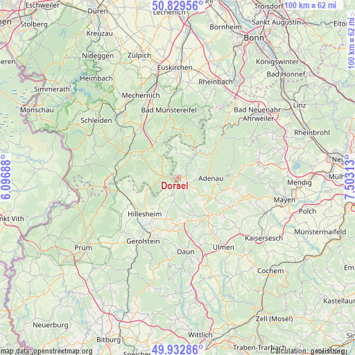
Dorsel GPS coordinates[2]
50° 22' 59.988" North, 6° 48' 0" East
| Map corner | latitude | longitude |
|---|---|---|
| Upper-left | 50.82956°, | 6.09688° |
| Center: | 50.38333°, | 6.8° |
| Lower-right: | 49.93286°, | 7.50313° |
| Map W x H: | 99.7×99.7 km | = 62×62mi |
| max Lat: | 55.01917° ⇑55% North |
| Dorsel: | 50.38333° |
| min Lat: | ⇓45% South 47.40724° |
| min Long | Dorsel | max Long |
| 5.92978° | 6.8° | 14.98853° |
| W 4.4%⇐ | ⇒95.6% E |
Elevation
Elevation of Dorsel is 382 m = 1253 ft, and this is 132.9 m = 436 ft above average elevation for this country.
| Max E: |
1256 m = 4121 ft | 27% |
| Dorsel | 382 m 1253 ft | |
| Avg. | 249.1 m = 817 ft | |
Min E: |
-5 m = -16 ft | 73% |
See also: Germany elevation on elevation.city.
Geographical zone
Dorsel is located in North temperate zone (between Tropic of Cancer and the Arctic Circle). Distance of this North polar circle is 1799.1 km =1117.9 mi to North.| Distance of | km | miles | from Dorsel |
|---|---|---|---|
| North Pole | 4405 | 2737.1 | to North |
| Arctic Circle | 1799.1 | 1117.9 | to North |
| Tropic Cancer | 2996.2 | 1861.8 | to South |
| Equator | 5602.1 | 3481 | to South |


Nearby cities:
15 places around Dorsel: (largest is in red/bold)
• Antweiler
3 km =1.9 mi,  51°
51°
• Aremberg
3.7 km =2.3 mi,  0°
0°
• Barweiler
5.1 km =3.2 mi,  111°
111°
• Dankerath
5.7 km =3.5 mi,  167°
167°
• Eichenbach
5.7 km =3.5 mi,  11°
11°
• Fuchshofen
6.2 km =3.9 mi,  35°
35°
• Hoffeld
2.2 km =1.4 mi,  147°
147°
• Müsch
2.4 km =1.5 mi,  90°
90°
• Nohn
5.7 km =3.5 mi,  192°
192°
• Pomster
4.5 km =2.8 mi,  137°
137°
• Reifferscheid
6.5 km =4 mi,  67°
67°
• Senscheid
6 km =3.7 mi,  156°
156°
• Trierscheid
3.9 km =2.4 mi, 162°
• Wirft
5.1 km =3.2 mi, 111°
• Üxheim
5.1 km =3.2 mi,  223°
223°
Sources, notices
• [Note1] Compared only with cities in Germany existing in our database
• [Src1] Map data: © OpenStreetMap contributors (CC-BY-SA)
• [Src2] Other city data from geonames.org with taken over terms of usage.
• [Src3] Geographical zone / Annual Mean Temperature by Robert A. Rohde @ Wikipedia
