Dörnberg geodata
Dörnberg (Rheinland-Pfalz) is a seat of a fourth-order administrative division; located in Germany in Europe/Berlin (GMT+2) time zone. With population of 600 people, there are 8822 cities with bigger population in this country. Compared to other cities in Germany, 56.1% of cities are located further ↑North; 79.2% of cities are located further →East and 59.8% of cities have lower elevation than Dörnberg. Note1


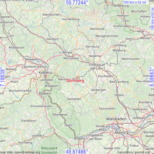
Dörnberg GPS coordinates[2]
50° 19' 32.412" North, 7° 53' 0.6" East
| Map corner | latitude | longitude |
|---|---|---|
| Upper-left | 50.77244°, | 7.18038° |
| Center: | 50.32567°, | 7.8835° |
| Lower-right: | 49.87466°, | 8.58663° |
| Map W x H: | 99.8×99.8 km | = 62×62mi |
| max Lat: | 55.01917° ⇑56.1% North |
| Dörnberg: | 50.32567° |
| min Lat: | ⇓43.9% South 47.40724° |
| min Long | Dörnberg | max Long |
| 5.92978° | 7.8835° | 14.98853° |
| W 20.8%⇐ | ⇒79.2% E |
Elevation
Elevation of Dörnberg is 289 m = 948 ft, and this is 39.9 m = 131 ft above average elevation for this country.
| Max E: |
1256 m = 4121 ft | 40.2% |
| Dörnberg | 289 m 948 ft | |
| Avg. | 249.1 m = 817 ft | |
Min E: |
-5 m = -16 ft | 59.8% |
See also: Germany elevation on elevation.city.
Geographical zone
Dörnberg is located in North temperate zone (between Tropic of Cancer and the Arctic Circle). Distance of this North polar circle is 1805.5 km =1121.9 mi to North.| Distance of | km | miles | from Dörnberg |
|---|---|---|---|
| North Pole | 4411.4 | 2741.1 | to North |
| Arctic Circle | 1805.5 | 1121.9 | to North |
| Tropic Cancer | 2989.8 | 1857.8 | to South |
| Equator | 5595.7 | 3477 | to South |


Nearby cities:
15 places around Dörnberg: (largest is in red/bold)
• Attenhausen
3.8 km =2.4 mi,  188°
188°
• Bremberg
3.4 km =2.1 mi,  129°
129°
• Charlottenberg
2 km =1.2 mi,  354°
354°
• Cramberg
4.6 km =2.9 mi,  67°
67°
• Geilnau
4.5 km =2.8 mi,  52°
52°
• Gutenacker
2.8 km =1.7 mi,  103°
103°
• Holzappel
2.9 km =1.8 mi,  23°
23°
• Horhausen
4.7 km =2.9 mi,  14°
14°
• Hübingen
4.5 km =2.8 mi,  324°
324°
• Laurenburg
2.1 km =1.3 mi, 69°
• Obernhof
2.6 km =1.6 mi,  247°
247°
• Scheidt
2.6 km =1.6 mi,  56°
56°
• Seelbach
1.6 km =1 mi,  230°
230°
• Weinähr
2.6 km =1.6 mi,  262°
262°
• Winden
3.7 km =2.3 mi,  283°
283°
Sources, notices
• [Note1] Compared only with cities in Germany existing in our database
• [Src1] Map data: © OpenStreetMap contributors (CC-BY-SA)
• [Src2] Other city data from geonames.org with taken over terms of usage.
• [Src3] Geographical zone / Annual Mean Temperature by Robert A. Rohde @ Wikipedia
