Seelbach geodata
Seelbach (Rheinland-Pfalz) is a seat of a fourth-order administrative division; located in Germany in Europe/Berlin (GMT+2) time zone. With population of 470 people, there are 9477 cities with bigger population in this country. Compared to other cities in Germany, 56.5% of cities are located further ↑North; 79.7% of cities are located further →East and 59.8% of cities have higher elevation than Seelbach. Note1


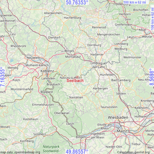
Seelbach GPS coordinates[2]
50° 19' 0.012" North, 7° 52' 0.012" East
| Map corner | latitude | longitude |
|---|---|---|
| Upper-left | 50.76353°, | 7.16355° |
| Center: | 50.31667°, | 7.86667° |
| Lower-right: | 49.86557°, | 8.5698° |
| Map W x H: | 99.8×99.8 km | = 62×62mi |
| max Lat: | 55.01917° ⇑56.5% North |
| Seelbach: | 50.31667° |
| min Lat: | ⇓43.5% South 47.40724° |
| min Long | Seelbach | max Long |
| 5.92978° | 7.86667° | 14.98853° |
| W 20.3%⇐ | ⇒79.7% E |
Elevation
Elevation of Seelbach is 154 m = 505 ft, and this is 95.1 m = 312 ft below average elevation for this country.
| Max E: |
1256 m = 4121 ft | 59.8% |
| Avg. | 249.1 m = 817 ft | |
| Seelbach | 154 m = 505 ft | |
Min E: |
-5 m = -16 ft | 40.2% |
See also: Germany elevation on elevation.city.
Geographical zone
Seelbach is located in North temperate zone (between Tropic of Cancer and the Arctic Circle). Distance of this North polar circle is 1806.5 km =1122.5 mi to North.| Distance of | km | miles | from Seelbach |
|---|---|---|---|
| North Pole | 4412.4 | 2741.7 | to North |
| Arctic Circle | 1806.5 | 1122.5 | to North |
| Tropic Cancer | 2988.8 | 1857.2 | to South |
| Equator | 5594.7 | 3476.4 | to South |


Nearby cities:
15 places around Seelbach: (largest is in red/bold)
• Attenhausen
2.8 km =1.7 mi,  167°
167°
• Bremberg
4 km =2.5 mi,  106°
106°
• Charlottenberg
3.2 km =2 mi,  18°
18°
• Dörnberg
1.6 km =1 mi,  50°
50°
• Gutenacker
3.9 km =2.4 mi,  85°
85°
• Holzappel
4.4 km =2.7 mi,  32°
32°
• Hübingen
4.9 km =3 mi,  342°
342°
• Kördorf
5.1 km =3.2 mi,  130°
130°
• Laurenburg
3.6 km =2.2 mi,  61°
61°
• Nassau
4.7 km =2.9 mi,  267°
267°
• Obernhof
1.2 km =0.7 mi, 270°
• Scheidt
4.2 km =2.6 mi, 54°
• Singhofen
5.3 km =3.3 mi,  206°
206°
• Weinähr
1.6 km =1 mi,  295°
295°
• Winden
3 km =1.9 mi,  308°
308°
Sources, notices
• [Note1] Compared only with cities in Germany existing in our database
• [Src1] Map data: © OpenStreetMap contributors (CC-BY-SA)
• [Src2] Other city data from geonames.org with taken over terms of usage.
• [Src3] Geographical zone / Annual Mean Temperature by Robert A. Rohde @ Wikipedia
