Charlottenberg geodata
Charlottenberg (Rheinland-Pfalz) is a seat of a fourth-order administrative division; located in Germany in Europe/Berlin (GMT+2) time zone. With population of 161 people, there are 10640 cities with bigger population in this country. Compared to other cities in Germany, 55.8% of cities are located further ↑North; 79.4% of cities are located further →East and 66.5% of cities have lower elevation than Charlottenberg. Note1
Administrative division(s):
- Level 1: Rheinland-Pfalz
- Level 3: Rhein-Lahn-Kreis
- Level 4: Charlottenberg


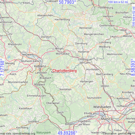
Charlottenberg GPS coordinates[2]
50° 20' 37.32" North, 7° 52' 50.916" East
| Map corner | latitude | longitude |
|---|---|---|
| Upper-left | 50.7903°, | 7.17768° |
| Center: | 50.3437°, | 7.88081° |
| Lower-right: | 49.89286°, | 8.58393° |
| Map W x H: | 99.8×99.8 km | = 62×62mi |
| max Lat: | 55.01917° ⇑55.8% North |
| Charlottenberg: | 50.3437° |
| min Lat: | ⇓44.2% South 47.40724° |
| min Long | Charlottenberg | max Long |
| 5.92978° | 7.88081° | 14.98853° |
| W 20.6%⇐ | ⇒79.4% E |
Elevation
Elevation of Charlottenberg is 332 m = 1089 ft, and this is 82.9 m = 272 ft above average elevation for this country.
| Max E: |
1256 m = 4121 ft | 33.5% |
| Charlottenberg | 332 m 1089 ft | |
| Avg. | 249.1 m = 817 ft | |
Min E: |
-5 m = -16 ft | 66.5% |
See also: Germany elevation on elevation.city.
Geographical zone
Charlottenberg is located in North temperate zone (between Tropic of Cancer and the Arctic Circle). Distance of this North polar circle is 1803.5 km =1120.6 mi to North.| Distance of | km | miles | from Charlottenberg |
|---|---|---|---|
| North Pole | 4409.4 | 2739.9 | to North |
| Arctic Circle | 1803.5 | 1120.6 | to North |
| Tropic Cancer | 2991.8 | 1859 | to South |
| Equator | 5597.7 | 3478.2 | to South |


Nearby cities:
15 places around Charlottenberg: (largest is in red/bold)
• Cramberg
4.4 km =2.7 mi,  92°
92°
• Dörnberg
2 km =1.2 mi,  174°
174°
• Gackenbach
2.7 km =1.7 mi,  338°
338°
• Geilnau
3.8 km =2.4 mi,  79°
79°
• Gutenacker
4 km =2.5 mi,  132°
132°
• Holzappel
1.5 km =0.9 mi,  62°
62°
• Horbach
3.8 km =2.4 mi,  328°
328°
• Horhausen
2.9 km =1.8 mi,  28°
28°
• Hübingen
3 km =1.9 mi,  303°
303°
• Laurenburg
2.5 km =1.6 mi,  120°
120°
• Obernhof
3.7 km =2.3 mi,  216°
216°
• Scheidt
2.4 km =1.5 mi,  103°
103°
• Seelbach
3.2 km =2 mi,  198°
198°
• Weinähr
3.3 km =2.1 mi,  225°
225°
• Winden
3.6 km =2.2 mi,  251°
251°
Sources, notices
• [Note1] Compared only with cities in Germany existing in our database
• [Src1] Map data: © OpenStreetMap contributors (CC-BY-SA)
• [Src2] Other city data from geonames.org with taken over terms of usage.
• [Src3] Geographical zone / Annual Mean Temperature by Robert A. Rohde @ Wikipedia
