Dollern geodata
Dollern (Lower Saxony) is a seat of a fourth-order administrative division; located in Germany in Europe/Berlin (GMT+2) time zone. With population of 1,728 people, there are 5460 cities with bigger population in this country. Compared to other cities in Germany, 85.9% of cities are located further ↓South; 57.1% of cities are located further →East and 86.6% of cities have higher elevation than Dollern. Note1


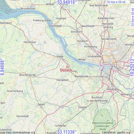
Dollern GPS coordinates[2]
53° 31' 59.988" North, 9° 33' 0" East
| Map corner | latitude | longitude |
|---|---|---|
| Upper-left | 53.94918°, | 8.84688° |
| Center: | 53.53333°, | 9.55° |
| Lower-right: | 53.11336°, | 10.25313° |
| Map W x H: | 92.9×92.9 km | = 57.7×57.7mi |
| max Lat: | 55.01917° ⇑14.1% North |
| Dollern: | 53.53333° |
| min Lat: | ⇓85.9% South 47.40724° |
| min Long | Dollern | max Long |
| 5.92978° | 9.55° | 14.98853° |
| W 42.9%⇐ | ⇒57.1% E |
Elevation
Elevation of Dollern is 31 m = 102 ft, and this is 218.1 m = 716 ft below average elevation for this country.
| Max E: |
1256 m = 4121 ft | 86.6% |
| Avg. | 249.1 m = 817 ft | |
| Dollern | 31 m = 102 ft | |
Min E: |
-5 m = -16 ft | 13.4% |
See also: Germany elevation on elevation.city.
Geographical zone
Dollern is located in North temperate zone (between Tropic of Cancer and the Arctic Circle). Distance of this North polar circle is 1448.8 km =900.2 mi to North.| Distance of | km | miles | from Dollern |
|---|---|---|---|
| North Pole | 4054.7 | 2519.5 | to North |
| Arctic Circle | 1448.8 | 900.2 | to North |
| Tropic Cancer | 3346.4 | 2079.4 | to South |
| Equator | 5952.3 | 3698.6 | to South |


Nearby cities:
15 places around Dollern: (largest is in red/bold)
• Agathenburg
3.3 km =2.1 mi,  338°
338°
• Bargstedt
9.9 km =6.2 mi,  221°
221°
• Bliedersdorf
5.7 km =3.5 mi,  168°
168°
• Deinste
7 km =4.3 mi,  266°
266°
• Grünendeich
5.8 km =3.6 mi,  45°
45°
• Guderhandviertel
4.3 km =2.7 mi,  65°
65°
• Harsefeld
9.4 km =5.8 mi,  199°
199°
• Hetlingen
10 km =6.2 mi,  35°
35°
• Horneburg
3.4 km =2.1 mi,  150°
150°
• Jork
8.6 km =5.3 mi,  90°
90°
• Mittelnkirchen
4.9 km =3 mi,  78°
78°
• Neuenkirchen
3.8 km =2.4 mi,  119°
119°
• Nottensdorf
6.5 km =4 mi, 149°
• Stade
8.3 km =5.2 mi,  323°
323°
• Steinkirchen
5.4 km =3.4 mi, 48°
Sources, notices
• [Note1] Compared only with cities in Germany existing in our database
• [Src1] Map data: © OpenStreetMap contributors (CC-BY-SA)
• [Src2] Other city data from geonames.org with taken over terms of usage.
• [Src3] Geographical zone / Annual Mean Temperature by Robert A. Rohde @ Wikipedia
