Agathenburg geodata
Agathenburg (Lower Saxony) is a seat of a fourth-order administrative division; located in Germany in Europe/Berlin (GMT+2) time zone. With population of 1,120 people, there are 6792 cities with bigger population in this country. Compared to other cities in Germany, 86.3% of cities are located further ↓South; 57.3% of cities are located further →East and 89.3% of cities have higher elevation than Agathenburg. Note1


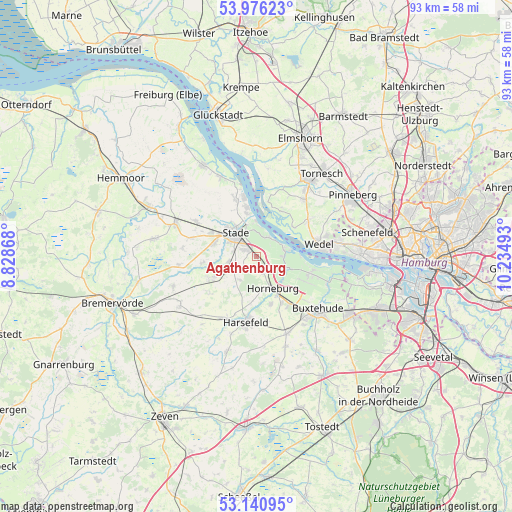
Agathenburg GPS coordinates[2]
53° 33' 38.34" North, 9° 31' 54.48" East
| Map corner | latitude | longitude |
|---|---|---|
| Upper-left | 53.97623°, | 8.82868° |
| Center: | 53.56065°, | 9.5318° |
| Lower-right: | 53.14095°, | 10.23493° |
| Map W x H: | 92.9×92.9 km | = 57.7×57.7mi |
| max Lat: | 55.01917° ⇑13.7% North |
| Agathenburg: | 53.56065° |
| min Lat: | ⇓86.3% South 47.40724° |
| min Long | Agathenburg | max Long |
| 5.92978° | 9.5318° | 14.98853° |
| W 42.7%⇐ | ⇒57.3% E |
Elevation
Elevation of Agathenburg is 23 m = 75 ft, and this is 226.1 m = 742 ft below average elevation for this country.
| Max E: |
1256 m = 4121 ft | 89.3% |
| Avg. | 249.1 m = 817 ft | |
| Agathenburg | 23 m = 75 ft | |
Min E: |
-5 m = -16 ft | 10.7% |
See also: Germany elevation on elevation.city.
Geographical zone
Agathenburg is located in North temperate zone (between Tropic of Cancer and the Arctic Circle). Distance of this North polar circle is 1445.8 km =898.4 mi to North.| Distance of | km | miles | from Agathenburg |
|---|---|---|---|
| North Pole | 4051.7 | 2517.6 | to North |
| Arctic Circle | 1445.8 | 898.4 | to North |
| Tropic Cancer | 3349.5 | 2081.3 | to South |
| Equator | 5955.4 | 3700.5 | to South |


Nearby cities:
15 places around Agathenburg: (largest is in red/bold)
• Bliedersdorf
8.9 km =5.5 mi,  164°
164°
• Deinste
6.8 km =4.2 mi,  238°
238°
• Dollern
3.3 km =2.1 mi, 158°
• Grünendeich
5.4 km =3.4 mi,  79°
79°
• Guderhandviertel
5.3 km =3.3 mi,  103°
103°
• Haseldorf
9.4 km =5.8 mi,  24°
24°
• Hetlingen
8.7 km =5.4 mi,  53°
53°
• Holm
10.9 km =6.8 mi,  55°
55°
• Horneburg
6.7 km =4.2 mi,  154°
154°
• Jork
10.3 km =6.4 mi,  107°
107°
• Mittelnkirchen
6.4 km =4 mi, 108°
• Neuenkirchen
6.6 km =4.1 mi,  137°
137°
• Nottensdorf
9.7 km =6 mi, 152°
• Stade
5.2 km =3.2 mi,  314°
314°
• Steinkirchen
5.3 km =3.3 mi, 83°
Sources, notices
• [Note1] Compared only with cities in Germany existing in our database
• [Src1] Map data: © OpenStreetMap contributors (CC-BY-SA)
• [Src2] Other city data from geonames.org with taken over terms of usage.
• [Src3] Geographical zone / Annual Mean Temperature by Robert A. Rohde @ Wikipedia
